Marsh Run (Oil Creek tributary) facts for kids
Quick facts for kids Marsh Run |
|
|---|---|
| Other name(s) | Tributary to Oil Creek |
| Country | United States |
| State | Pennsylvania |
| County | Crawford |
| City | Hydetown |
| Physical characteristics | |
| Main source | divide between Marsh Run and Muddy Creek near McGinnet Corners, Pennsylvania 1,600 ft (490 m) 41°43′30″N 079°48′12″W / 41.72500°N 79.80333°W |
| River mouth | about 0.5 miles south of Tryonville, Pennsylvania Tryonville, Pennsylvania 1,250 ft (380 m) 41°41′05″N 079°46′59″W / 41.68472°N 79.78306°W |
| Length | 4.0 mi (6.4 km) |
| Basin features | |
| Progression | southeast |
| River system | Allegheny River (Oil Creek) |
| Basin size | 4.0 square miles (10 km2) |
| Tributaries |
|
| Bridges | Armstrong Road Old Grade Road Tryonville Road |
Marsh Run is a small stream, or "run," located in Crawford County, Pennsylvania, in the United States. It flows for about 4.0 miles (6.4 km) and is an important part of the local water system. This stream eventually joins a larger one called Oil Creek.
Contents
Journey of Marsh Run
Marsh Run starts its journey high up, about 1,600 feet (488 meters) above sea level. This starting point is near a place called McGinnet Corners, Pennsylvania. It begins where the land divides the water flow between Marsh Run and another stream called Muddy Creek.
Flowing Through the Land
As Marsh Run travels, it flows generally towards the southeast. It passes through areas like Hydetown. Along its path, other smaller streams might join it, adding to its water. One such stream is DeWolfe Run, which flows into Marsh Run from the right side.
Where Marsh Run Ends
After its 4.0-mile (6.4 km) journey, Marsh Run reaches its end. It flows into Oil Creek, which is a much larger stream. This meeting point is about 0.5 miles south of Tryonville, Pennsylvania. At this spot, Marsh Run is about 1,250 feet (381 meters) above sea level. Oil Creek then continues its journey until it joins the Allegheny River. This means Marsh Run is part of the larger Allegheny River system.
The Area Around Marsh Run
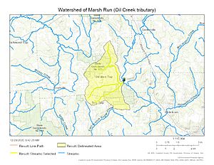
The land that collects rainwater and sends it into Marsh Run is called its "basin" or "watershed." For Marsh Run, this area covers about 4.0 square miles (10 square kilometers). This basin includes all the land where rain or snowmelt will eventually flow into Marsh Run.
Crossing the Stream
Even though Marsh Run is a smaller stream, several roads cross over it. These crossings are made possible by bridges. Some of the bridges you might find over Marsh Run include those on Armstrong Road, Old Grade Road, and Tryonville Road. These bridges help people travel easily across the stream.
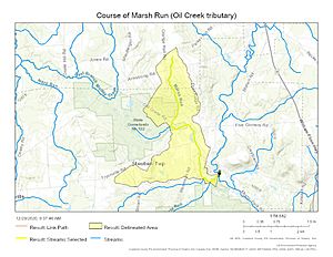
Maps of Marsh Run
To better understand where Marsh Run is and how it flows, maps are very helpful.
 | Selma Burke |
 | Pauline Powell Burns |
 | Frederick J. Brown |
 | Robert Blackburn |


