Matoaca, Virginia facts for kids
Quick facts for kids
Matoaca, Virginia
|
|
|---|---|

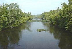
The Appomattox River at Matoaca
|
|

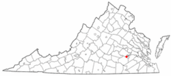
Location of Matoaca, Virginia
|
|
| Country | United States |
| State | Virginia |
| County | Chesterfield |
| Area | |
| • Total | 2.7 sq mi (6.9 km2) |
| • Land | 2.5 sq mi (6.6 km2) |
| • Water | 0.1 sq mi (0.3 km2) |
| Elevation | 141 ft (43 m) |
| Population
(2010)
|
|
| • Total | 2,403 |
| • Density | 890/sq mi (348.3/km2) |
| Time zone | UTC−5 (Eastern (EST)) |
| • Summer (DST) | UTC−4 (EDT) |
| FIPS code | 51-50136 |
| GNIS feature ID | 1497010 |
Matoaca is a community in Chesterfield County, Virginia, United States. It is known as a census-designated place (CDP). In 2010, about 2,400 people lived here.
The name "Matoaca" comes from a famous Pamunkey princess. Her real name was Matoaka, but she was better known as "Pocahontas". It is believed that Matoaca is near where her childhood village, Matoka or Matoks, once stood.
In 2016, Matoaca was even listed as one of the top 50 best places to live in the United States by CNN Money.
Contents
History of Matoaca
Matoaca has an interesting past. A historic place called Olive Hill was added to the National Register of Historic Places in 1975. This means it is a special place recognized for its history.
The Appomattox River's Role
The Appomattox River is very important to Matoaca's history. This river is almost 160 miles long. Long ago, early colonists used it as a travel path. Its name comes from the Native American tribe that lived along its banks.
Because the Appomattox River flows into the James River, it was a key port during the American Civil War. Large ships could dock there. In the spring of 1865, during the Appomattox Campaign, Confederate soldiers tried to stop the Union Army. They attempted to burn a high bridge over the Appomattox River. They failed, and the Confederate Army later surrendered at Appomattox Court House.
Geography of Matoaca
Matoaca is located in Virginia. Its exact coordinates are 37°13′41″N 77°28′14″W / 37.22806°N 77.47056°W.
The community covers about 2.7 square miles (about 6.9 square kilometers). Most of this area is land, with a small part being water.
People of Matoaca
In 2000, about 2,273 people lived in Matoaca. There were 866 households, which are groups of people living together.
Many families lived in Matoaca. About 34% of households had children under 18. The average household had about 2.6 people.
The population included people of different ages. About 27% were under 18. Around 14% were 65 years old or older. The average age of people in Matoaca was 38 years.
Education in Matoaca
Matoaca has its own local schools. These are part of the Chesterfield County Public Schools system.
The schools serving the community are:
- Matoaca Elementary School
- Matoaca Middle School
- Matoaca High School
Most adults in Matoaca have finished high school. About 89% of residents have a high school diploma. Even though it's a smaller community, nearly 1,500 people living there are currently enrolled in school. Many residents have also gone on to college. About 10% have earned a college degree.
See also
 In Spanish: Matoaca (Virginia) para niños
 | John T. Biggers |
 | Thomas Blackshear |
 | Mark Bradford |
 | Beverly Buchanan |

