
Matt, Switzerland facts for kids
Quick facts for kids
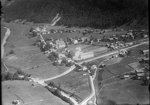
Matt
|
||
|---|---|---|
|
Village (and former municipality)
|
||
 |
||
|
||

The former municipal area (2007)
|
||
| Country | Switzerland | |
| Canton | Glarus | |
| Municipality | Glarus Süd | |
| Area | ||
| • Total | 41.27 km2 (15.93 sq mi) | |
| Elevation | 831 m (2,726 ft) | |
| Population
(December 2020)
|
||
| • Total | 361 | |
| • Density | 8.747/km2 (22.66/sq mi) | |

Matt is a charming village in Switzerland. It used to be its own town, but now it is part of the larger municipality of Glarus Süd. Matt is nestled in the valley of the Sernf river. The village includes Matt itself and a small mountain area called Weissenberge.
Contents
Matt's Past: A Look at Its History

Matt was first written about in the year 1273. Back then, it was called Mattun.
How Matt Got Connected: Trains and Trams
In 1879, the main Linth river valley got a railway line. This connected the area to the rest of Switzerland. However, Matt, which is in a side valley, did not have a train station. This made it harder for people and goods to travel.
So, on July 8, 1905, a special electric tramway opened. It was called the Sernftal tramway. This tram connected Matt to Schwanden and other towns like Elm. The tram ran until May 31, 1969. After that, buses took over the route.
In 1967, a cable car was built. This made it easy to travel between Matt and the mountain hamlet of Weissenberge.
Becoming Part of Glarus Süd
On January 1, 2011, Matt joined with other towns to form the new municipality of Glarus Süd.
Exploring Matt: Geography and Nature

The village of Matt is about 831 meters (2,726 feet) above sea level. It sits on the right side of the Sernf river. The small mountain area of Weissenberge is higher up, at about 1,266 meters (4,154 feet).
Matt is located along the road that connects Schwanden and Elm. The village of Engi is north of Matt, and Elm is to the south. A stream called Krauch flows into the Sernf river near Matt.
Matt's Land and Mountains
The area of Matt, based on its old boundaries, is about 41.3 square kilometers (15.9 square miles). This covers a large area on both sides of the river. To the east, the land goes up to high mountain peaks. These include the Gulderstock (2,511 meters or 8,238 feet) and the Foostock (2,611 meters or 8,566 feet). The valley of the Krauch stream is also in this eastern part.
To the west, the land rises to the Bergligrat, which is 2,428 meters (7,966 feet) high.
How the Land is Used
Almost 40% of Matt's land is used for farming. About 32% is covered by forests. A small part, less than 1%, has buildings or roads. The rest, about 27%, is made up of rivers, glaciers, or mountains.
The Riseten Pass: A Mountain Connection
The Riseten Pass is a mountain path that connects Matt to the village of Weisstannen. This pass is a hiking trail. It crosses between the Wissgandstöckli and Foostock peaks at an elevation of 2,189 meters (7,182 feet).
Getting Around: Transport in Matt
Bus Services
The Sernftalbus runs a bus service every hour. This bus connects Matt to the Schwanden railway station, Elm, and other communities. This bus service replaced the old Sernftal tramway that ran from 1905 to 1969. At Schwanden railway station, you can catch a train to Glarus, the capital of the canton.
Cable Car to Weissenberge
A cable car also connects the village of Matt to the higher-up hamlet of Weissenberge.
People of Matt: Demographics and Life
Matt has a population of 361 people (as of 31 December 2020). In 2007, about 3.3% of the people living in Matt were from other countries. Over the past ten years, the population has decreased slightly.
Languages Spoken
Most people in Matt speak German, about 93.2% of the population. Albanian is the second most common language, spoken by 3.7% of people. Italian is the third most common, spoken by 1.3%.
Education and Jobs
About 70% of adults in Matt (aged 25-64) have finished high school or gone on to higher education. This includes university or a special college called a Fachhochschule.
Matt has a low unemployment rate of 0.94%. In 2005, many people worked in farming. There were also jobs in manufacturing and services.
Population Over Time
Here is how Matt's population has changed over the years:
| year | population |
|---|---|
| 1777 | 257 |
| 1850 | 659 |
| 1900 | 690 |
| 1950 | 622 |
| 2000 | 381 |
See also
 In Spanish: Matt para niños
