
Schwanden, Glarus facts for kids
Quick facts for kids
Schwanden
|
||
|---|---|---|
|
Village (and former municipality)
|
||
 |
||
|
||

The former municipal area (2007)
|
||
| Country | Switzerland | |
| Canton | Glarus | |
| Municipality | Glarus Süd | |
| Area | ||
| • Total | 30.63 km2 (11.83 sq mi) | |
| Elevation | 528 m (1,732 ft) | |
| Population
(December 2010)
|
||
| • Total | 2,392 | |
| • Density | 78.093/km2 (202.26/sq mi) | |

Schwanden is a charming village located in the Glarus Süd area of the canton of Glarus in Switzerland. It used to be its own separate town, but now it's part of the larger Glarus Süd municipality.
Contents
History of Schwanden
Schwanden was first written about in the year 1240. Back then, it was called de swando.
In 1879, Schwanden got its first train connection. This was thanks to the Swiss Northeastern Railway line from Weesen. Later, from 1905 to 1969, a special tramway called the Sernftal tramway helped people travel. It connected Schwanden to other towns in the Sernf river valley, all the way to Elm.
On January 1, 2011, Schwanden joined the larger municipality of Glarus Süd. This means it became part of a bigger local government area.
Geography and Nature

Schwanden is located about 528 meters (1,732 feet) above sea level. It sits right where two rivers meet: the Linth and the Sernf. The village is on the main roads that lead to places like Elm, Linthal, and Schwändi. It also includes a small area called Thon, which used to be a separate hamlet until 1876.
Nearby villages include Nidfurn and Haslen to the south, in the Linth valley. To the east, you'll find Engi in the Sernf valley. North of Schwanden is Mitlödi, also in the Linth valley. On the valley slopes, you can see Schwandi to the west and Sool to the east.
South of Schwanden is a special protected area called the Freiberg Kärpf. It's the oldest Jagdbanngebiet (which means "hunting-banned area") in Switzerland. It has been protected since 1548. Also to the south, a stream called Niederenbäch flows down from the Kärpf mountain, which is 2,794 meters (9,167 feet) high. This stream has been dammed to create the Garichtisee reservoir.
In 2006, Schwanden's former municipal area covered about 30.6 square kilometers (11.8 square miles). A good part of this land, about 32.3%, is used for farming. Forests cover 38.3% of the area. About 3.2% of the land has buildings or roads, and the remaining 26.2% is made up of non-productive areas like rivers, glaciers, or mountains.
Travel and Transportation
Schwanden is on the Hauptstrasse 17, a main road that goes through the whole canton of Glarus. This road then climbs over the Klausen Pass into the canton of Uri. Schwanden is also on the Weesen to Linthal railway line, which runs next to the main road and the Linth river.
A smaller road branches off Hauptstrasse 17 in Schwanden. It goes up the Sernf valley, connecting to the towns there. However, there's no road that goes beyond the very end of that valley. The high mountain Klausen Pass is usually only open from June to September. For the rest of the year, the road and railway up the Linth valley are the only ways to get to Schwanden.
The village has its own train stop, Schwanden railway station. This station is a stop for the Zürich S-Bahn service S25, which travels between Linthal and Zürich. It's also the final stop for the St. Gallen S-Bahn service S6 from Rapperswil. As of December 2023, both train services run once every hour. This means there are two trains per hour between Ziegelbrücke and Schwanden.
The Sernftalbus company runs several bus services from Schwanden station:
- A bus goes every hour up the Sernf river valley to Glarus. This bus route replaced the old Sernftal tramway.
- Another bus goes every hour to Schwändi.
- There's also a bus service to Sool, which runs a few times a day.
- During the summer, a special bus service runs a few times a day. It connects to an aerial tramway that takes you up to the Garichtisee lake.
People and Community

As of 2010, Schwanden had a population of 2,392 people. In 2007, about 24.2% of the people living there were from other countries. Over the past 10 years, the population has slightly decreased. Most people in Schwanden (about 82.7% in 2000) speak German. Italian is the second most common language (5.1%), followed by Albanian (2.9%).
In the 2007 national election, the most popular political party was the SPS, which got 59% of the votes. The SVP received most of the remaining votes, with 31.6%.
About 60.6% of the people in Schwanden aged 25 to 64 have finished higher education. This means they have either completed advanced schooling after high school or gone to a university.
Schwanden has a low unemployment rate of 2.18%. In 2005, there were 39 people working in farming and related businesses. The manufacturing and industry sector employed 1,067 people across 45 businesses. The service sector, which includes jobs like retail and tourism, employed 525 people in 92 businesses.
Here's a look at how the population of Schwanden has changed over time:
| year | population |
|---|---|
| 1574 | 450 |
| 1763 | 1,148 |
| 1850 | 2,296 |
| 1900 | 2,396 |
| 1960 | 3,020 |
| 1990 | 2,645 |
Images for kids
-
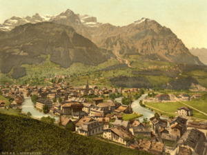
A view of Schwanden
-
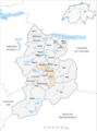
Map of the former municipal area of Schwanden (2007)
-
The coat of arms for Schwanden
See also
 In Spanish: Schwanden para niños
