
Mawson Plateau facts for kids
The Mawson Plateau is a special place in the northern Flinders Ranges of South Australia. It's located on a large property called Mount Freeling, about 140 kilometers (87 miles) east of Lyndhurst. It's also right next to the northeastern edge of Arkaroola. This area is known for its beautiful, rugged landscape.
Contents
What is the Mawson Plateau?
The Mawson Plateau is a big area of granite rock, covering about 71 square kilometers (27 square miles). It sits high up, between 600 and 750 meters (about 2,000 to 2,500 feet) above sea level. Two creeks, Saucepan Creek and Granite Plateau Creek, flow through it. These creeks eventually join the larger Hamilton Creek. The plateau is surrounded by Hamilton Creek to the north and west, a high ridge called the Granite Escarpment to the east, and Freeling Heights to the south.
How Places Got Their Names


The Mawson Plateau was originally known as the Freeling Heights lower granite plateau. It was later renamed after a famous explorer, Sir Douglas Mawson.
The main creek on the plateau has always been called Granite Plateau Creek by the people who owned the Mount Freeling property.
T Junction Waterhole is a waterhole found about 100 meters downstream from a unique T-shaped bend in Granite Plateau Creek. In the early 1980s, the owners of the nearby Arkaroola property stored emergency food supplies here.
The Granite Escarpment is a tall ridge of weathered granite that looks out over Lake Frome. It's a very striking natural feature.
In a deep valley along Granite Plateau Creek, there's a tall granite cliff known to hikers as Aqualung Wall. At the bottom of this cliff, there are waterholes that always have water. You can find water spiders (Dolomedes spp.) living there. The cliff got its name because these spiders can go underwater to hunt or hide, breathing from air bubbles attached to their bodies.
Edmunds Hill is a small peak on the central plateau. From here, you can see amazing 360-degree views of the entire plateau. It's named after Lorraine Edmunds, who worked for Arkaroola and was a dedicated conservationist.
Many waterholes are found along the creeks on the Mawson Plateau. Most of them are temporary and only fill up after enough rain.
Ray's Waterhole is a beautiful waterhole on Saucepan Creek that always has water.
The plateau is a wild and remote area, so it's rare to find modern human items there. However, sometimes old items are found near important spots, and they can even help name a place:
Stardrop Waterhole is a waterhole upstream from Tee Junction Waterhole. It got its name because a single steel fence post, called a "star dropper," was found there.
Saucepan Creek is a major stream that flows into Granite Plateau Creek. It's named after two saucepans that were found at different times and places along the creek. One was found hanging from a river red gum tree where Saucepan Creek meets Granite Plateau Creek. The other was found near a large waterfall on Saucepan Creek.
Climate and Weather

The Mawson Plateau is in a very dry part of Australia. The average rainfall in the nearby Arkaroola area is about 265 millimeters (10.4 inches) per year. However, studies have shown that places higher up, like the Mawson Plateau (around 700 meters or 2,300 feet high), likely get more rain.
Most of the extra rain at higher altitudes happens in winter. But the area also gets strong, unpredictable summer storms. These storms can cause big differences in how much rain falls each year. For example, Arkaroola has recorded as little as 56 millimeters (2.2 inches) and as much as 949 millimeters (37.4 inches) of rain in different years! Similar big changes in rainfall happen on the Mawson Plateau too.
Water Life
The Mawson Plateau acts like a giant funnel, collecting water for Granite Plateau Creek and Saucepan Creek. These creeks only flow for a short time after it rains. Since the rainfall changes a lot, water is hard to find for most of the year, and both creeks often dry up.
In some spots, the creeks have carved deep valleys and gorges into the granite. These areas create waterholes that stay wet all year or for a long time. These permanent and semi-permanent waterholes are home to many different animals. You can find various types of frogs, including the brown toadlet, water spiders (Dolomedes spp.), and small groups of fish. The fish might be spangled perch, which are common desert fish, or Lake Eyre Hardyhead, which are often found in the Flinders Ranges.
Animals of the Plateau
Even though there's some permanent water, large mammals and birds are not very common on the plateau. However, you can find small groups of euros (a type of wallaroo), echidnas, and a few kinds of bats. Wild goats are rare here.
Common birds include the willie wagtail, the huge wedge-tailed eagle, and the Australian boobook owl.
Reptiles, like snakes, skinks, and dragons, are much more common than mammals on the Mawson Plateau.
Images for kids
-
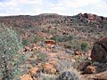
Typical Mawson Plateau terrain; rolling hills, with sparse vegetation interspersed with numerous eroded granite boulders.
-
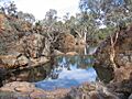
Waterhole on the Granite Plateau Creek; the more permanent of these waterholes support small populations of unidentified fish.


