Mayarí facts for kids
Quick facts for kids
Mayarí
|
|
|---|---|

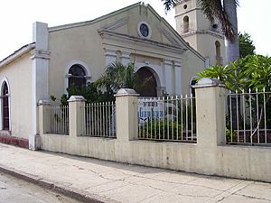
San Gregorio Nacianceno church
|
|

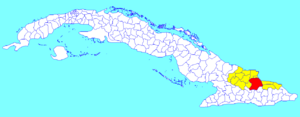
Mayarí municipality (red) within
Holguín Province (yellow) and Cuba |
|
| Country | Cuba |
| Province | Holguín |
| Founded | 1757 |
| Established | January 19, 1879 (Municipality) |
| Area | |
| • Total | 1,307 km2 (505 sq mi) |
| Elevation | 15 m (49 ft) |
| Population
(2022)
|
|
| • Total | 92,792 |
| • Density | 70.996/km2 (183.88/sq mi) |
| Time zone | UTC-5 (EST) |
| Area code(s) | +53-24 |
Mayarí is an important town and municipality located in the Holguín Province of Cuba. It is known for its natural beauty and interesting history.
Contents
History of Mayarí
Early Beginnings in Mayarí
The town of Mayarí began a long time ago, in 1757. This was when Cuba was a Spanish colony. The first farms were started here by people who came to live in the area.
Becoming a Municipality
Mayarí grew over the years. On January 19, 1879, it officially became the center of the Mayarí Municipality. This meant it became an important local government area.
Geography and Local Areas
Understanding Mayarí's Layout
The Mayarí municipality is divided into many smaller areas. These areas are called barrios and hamlets. Some of these include Barajagua, Cabonico, and Guayabo.
Famous Birthplace Nearby
The town of Birán was once part of Mayarí. This is a very famous place because it is the birthplace of Fidel Castro and Raúl Castro. They were important leaders in Cuba's history. In 1976, Birán became part of the nearby Cueto municipality.
Other Interesting Neighborhoods
Mayarí has other notable neighborhoods too.
- Felton is on Cajimaya Bay. It used to be a busy seaport for a large iron mining company.
- Guatemala (once called Preston) is on Nipe Bay. It was home to a big sugar mill run by a major fruit company.
- Nicaro-Levisa is on Levisa Bay. It was originally named Lengua de Pajaro, which means "bird's tongue" in English. This name came from how it looked from above.
These areas were important for mining and sugar production in the early 1900s. Nickel and cobalt were mined in places like Mina Martí, showing Mayarí's role in industry.
Population of Mayarí
In 2022, the municipality of Mayarí was home to 92,792 people. The total area of the municipality is about 1,307 square kilometers (505 square miles). This means that about 71 people live in each square kilometer.
Places to Explore in Mayarí
Sierra Cristal National Park
Part of the beautiful Sierra Cristal National Park is located in the Mayarí Municipality. This park is a great place to see nature and wildlife. It is also partly in the neighboring Sagua de Tánamo Municipality.
Discover Cayo Saetía
Another amazing place to visit is Cayo Saetía. This is a scenic cay (a small, low island or reef) with lovely beaches. It is located within the municipality, on the Bay of Nipe, north of Mayarí city. It's a perfect spot for outdoor adventures.
See also
 In Spanish: Mayarí para niños
 | John T. Biggers |
 | Thomas Blackshear |
 | Mark Bradford |
 | Beverly Buchanan |

