Mayo, Maryland facts for kids
Quick facts for kids
Mayo, Maryland
|
|
|---|---|

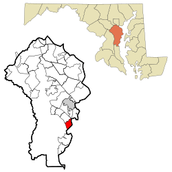
Location of Mayo, Maryland
|
|
| Country | |
| State | |
| County | |
| Area | |
| • Total | 9.44 sq mi (24.46 km2) |
| • Land | 5.62 sq mi (14.55 km2) |
| • Water | 3.82 sq mi (9.90 km2) |
| Elevation | 13 ft (4 m) |
| Population
(2020)
|
|
| • Total | 8,832 |
| • Density | 1,571.81/sq mi (606.83/km2) |
| Time zone | UTC−5 (Eastern (EST)) |
| • Summer (DST) | UTC−4 (EDT) |
| ZIP code |
21106
|
| Area code(s) | 410, 443, and 667 |
| FIPS code | 24-51575 |
| GNIS feature ID | 0590767 |
Mayo is a special kind of community in Anne Arundel County, Maryland, United States. It's called a census-designated place (CDP). This means it's an area that the government counts for population, but it's not officially a city or town.
In 2010, about 8,298 people lived in Mayo. By 2020, the population grew to 8,832. The area known as Mayo today includes a place that used to be called Selby-on-the-Bay. Long ago, the beach in Mayo was a very popular spot for weekend trips.
Contents
Exploring Mayo's Location and Features
Mayo is located in Maryland, just south of Annapolis. It sits on a piece of land that has water on two sides. To the northeast is the South River, and to the southwest is the Rhode River. Both of these rivers are connected to the Chesapeake Bay.
Mayo is next to Edgewater to the northwest. Across the South River, you'll find Annapolis Neck. Mayo has many smaller neighborhoods within it, like Saunder's Point, Shoreham Beach, Beverly Beach, and Selby Beach.
The main road that goes through Mayo is Maryland Route 214. This road ends at Beverly Beach, right on the Chesapeake Bay.
Understanding Mayo's Size
The total area of Mayo is about 24.5 square kilometers (about 9.4 square miles). Most of this area is land, which is about 14.6 square kilometers (5.6 square miles). The rest, about 9.9 square kilometers (3.8 square miles), is water. This means that about 40% of Mayo's total area is water!
Who Lives in Mayo?
| Historical population | |||
|---|---|---|---|
| Census | Pop. | %± | |
| 2010 | 8,298 | — | |
| 2020 | 8,832 | 6.4% | |
| U.S. Decennial Census | |||
Mayo's Population in 2010
In 2010, the total population of Mayo was 8,298 people. Most of the people living in Mayo were White, making up about 93% of the population. About 3% of the population was Hispanic, and 2% identified as two or more races. African Americans made up about 1% of the population.
A Look at Mayo's Past
Mayo got its name from a brave naval officer named Commodore Isaac Mayo. He was famous for his actions during the Mexican–American War. Commodore Mayo owned a very large piece of land along the South River. In the early 1900s, this land was known as "Mayo's Neck."
This land was once the home of Captain Nicholas Gassaway, whose father was a well-known Maryland politician named Colonel Nicholas Gassaway. The Gassaway family home, called Gresham, is a historic building. It was added to the National Register of Historic Places in 1990, meaning it's an important place to protect and remember.
Famous People from Mayo
Mayo has been home to some notable people:
- Jacob Bender: An American football player.
- Phillip D. Bissett: An American politician who served in the Maryland House of Delegates.
See also
 In Spanish: Mayo (Maryland) para niños
 | Toni Morrison |
 | Barack Obama |
 | Martin Luther King Jr. |
 | Ralph Bunche |

