McAfee Knob facts for kids

McAfee Knob is a famous spot on Catawba Mountain in Catawba, Virginia. It stands about 3,197 feet (974 meters) above sea level. This special place is named after an early settler from the 1700s.
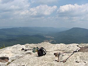
McAfee Knob is one of the most well-known points along the Appalachian Trail. From here, you can see amazing views of the Catawba Valley, which is about 1,600 feet (488 meters) below. It's a favorite spot for hikers and photographers!
Contents
About McAfee Knob
- A "knob" is a rounded hill or mountain. You often find them in older mountain ranges.
- McAfee Knob got its name from James McAfee. He was an immigrant from Scotland and Ireland who settled in the Catawba Valley around the late 1730s.
- This knob is the tallest mountain in the Catawba area. It reaches almost 3,200 feet (975 meters) high.
- In the mid-1900s, much of Catawba Mountain was open farmland.
- Today, the ridge of McAfee Knob is covered with a thick pine forest.
- Many people say McAfee Knob is the most photographed spot on the entire Appalachian Trail.
The Appalachian Trail
McAfee Knob is right on the Appalachian Trail, often called the "A.T." You can hike to it from different directions. It's a 4-mile (6.4 km) hike north from the VA-311 road in Catawba, Virginia. Or, it's a longer 16-mile (25.7 km) hike south from US-220 in Troutville, Virginia.
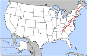
The Appalachian Trail is a super long hiking path. It stretches for about 2,190 miles (3,524 km)! It follows the Appalachian Mountains all the way from Georgia to Maine. The National Park Service helps manage this huge trail.
The part of the trail that goes to McAfee Knob is looked after by the Appalachian Trail Conservancy. This area is just one small piece of over 120 miles (193 km) of hiking trails in the Roanoke region. Volunteers from the Roanoke Appalachian Trail Club (RATC) work hard to keep these trails in great shape.
Hiking McAfee Knob
What the Hike is Like
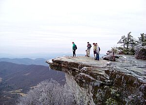
The hike to McAfee Knob is considered moderately difficult. It has a steady uphill climb. The trail ends on a rocky part of the mountain that sticks out like a platform. From here, you get a 270-degree view of the beautiful Catawba Valley.
You can also see North Mountain to the west, the Tinker Cliffs to the north, and the Roanoke Valley to the east. The climb is about 1,700 feet (518 meters) up. It's about 4.7 miles (7.6 km) to the top from the VA-311 parking area.
As you hike up the 4.4-mile (7.1 km) trail, the weather can change. It gets colder at the top because of the higher altitude. So, it's a good idea to bring an extra jacket or layer of clothing. The whole hike, up and down, usually takes about 4 to 4.5 hours. Make sure to bring plenty of water and snacks!
You'll find picnic tables and spots to rest along the trail. McAfee Knob is most popular in the spring and fall. On busy days, there can be around 100 hikers on the trail at once.
If you hike in the winter, you might find you're almost alone! You might also see cool frost formations. These are called "rime ice" and "hoarfrost." Rime ice forms when wind blows tiny water droplets onto objects like tree branches, and they freeze. Hiking in winter is a very different experience from hiking in spring!
How to Get There
The main parking area for the trailhead is on VA-311. Be careful if you use a map app like Google Maps. Some directions might send you to Rt. 779, but this is wrong. That road leads to private land, not McAfee Knob.
These parking lots can get full very early, especially on weekends and holidays.
To get to the VA-311 parking lot from Roanoke:
- Take I-81 south to exit 141.
- Turn left onto Virginia Route 419, also called Electric Road.
- Go about 0.4 miles (0.6 km) to Virginia Route 311.
- Turn right and drive about 5.6 miles (9.0 km). The A.T. access parking lot will be on your left at the top of Catawba Mountain.
- Be very careful when crossing VA-311. Cars drive fast here, with a speed limit of 55 mph (88 km/h).
Once you're at the parking area:
- From the right side of the Appalachian Trail, cross over to the VA-311 parking area.
- Walk about 0.3 miles (0.5 km) north. You'll see an information kiosk on your left.
- Keep walking on the Appalachian Trail. You'll cross four wooden walkways before reaching the Johns Spring Shelter in about 1.4 miles (2.3 km).
- Go another 0.1 miles (0.2 km). You'll see a shelter on your left and a spring with water coming from a white pipe.
- Stay on this path for another 0.1 miles (0.2 km). You'll find two campsites. The trail turns left just before these overnight sites.
- Keep going on the trail. You'll come to an old fire road near a clearing for power lines.
- About 0.3 miles (0.5 km) after the power line, there's an overlook on your left with a view of the Catawba Valley.
- Continue 0.5 miles (0.8 km) further up the trail to the McAfee Knob Spur Trail.
- Turn left. In less than 30 yards (27 meters), you'll be at the top of the Knob! Enjoy the 270-degree panoramic view of the Roanoke Valley, North Mountain, and Tinker Cliffs.
There are several places where you can camp overnight, like the Campbell Shelter. This shelter has many spots and an outhouse (a simple toilet). A water source is about 0.1 miles (0.2 km) behind the shelter. Remember, you are not allowed to camp or have campfires right around McAfee Knob's cliffs and rocks.
Important Rules for Hikers
McAfee Knob is part of the Appalachian Trail, which is managed by the National Park Service. Here are some rules to follow:
- Group Size: If you are backpacking or camping, your group can have a maximum of 10 people. For day hikes, the maximum group size is 25 people.
- Alcohol: No alcohol is allowed.
- Dogs: Dogs must always be on a leash.
- Camping and Campfires: You cannot camp or have campfires on McAfee Knob itself. You can only camp in seven special areas. These are Johns Spring Shelter, Catawba Shelter and campsites, Pig Farm campsite, Campbell Shelter, and Lambert’s Meadow Shelter and campsites.
The McAfee Knob Task Force
In 2015, a group called the McAfee Knob Task Force was created. This group has 18 members. They help the Appalachian Trail Conservancy's "Ridge runners" patrol the trail. They also help at other popular hiking spots nearby, like Dragon's Tooth and Tinker Cliffs.
In one year, these volunteers spent over 500 hours working on the trail. They counted more than 9,000 visitors and talked to over 5,000 of them. They also collected and removed 54 gallons (204 liters) of trash! Their work helps keep the trail clean and safe for everyone.
Gallery
The overlook gives you a 270-degree view of the Catawba Valley. McAfee Knob is known as the most photographed spot on the A.T.
 | Frances Mary Albrier |
 | Whitney Young |
 | Muhammad Ali |


