McCandless, Pennsylvania facts for kids
Quick facts for kids
McCandless, Pennsylvania
|
|||
|---|---|---|---|
|
Home rule municipality
|
|||

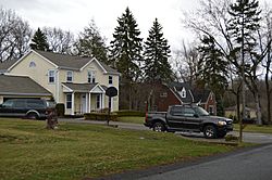
Typical suburban street
|
|||
|
|||

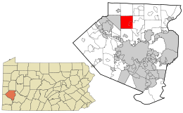
Location in Allegheny County and state of Pennsylvania
|
|||
| Country | United States | ||
| State | Pennsylvania | ||
| County | Allegheny | ||
| Settled | 1796 | ||
| Incorporated | 1851 | ||
| Government | |||
| • Type | Town Council | ||
| Area | |||
| • Total | 16.60 sq mi (43.00 km2) | ||
| • Land | 16.50 sq mi (42.73 km2) | ||
| • Water | 0.10 sq mi (0.27 km2) | ||
| Elevation | 1,024 ft (312 m) | ||
| Population
(2020)
|
|||
| • Total | 29,709 |
||
| • Estimate
(2022)
|
29,038 | ||
| • Density | 1,742.83/sq mi (672.92/km2) | ||
| Time zone | UTC−5 (Eastern (EST)) | ||
| • Summer (DST) | UTC−4 (EDT) | ||
| ZIP Code |
15237, 15090, 15044, 15101, 15127
|
||
| Area code(s) | 412, 724, 878 | ||
| FIPS code | 42-003-45900 | ||
| Website | McCandless official website: http://www.townofmccandless.org | ||
McCandless is a township in Allegheny County, Pennsylvania, United States. It's like a town with its own local government. In 2020, about 29,709 people lived there. McCandless is a northern suburb of the big city of Pittsburgh. It's known for being a great place to live.
McCandless is part of the North Allegheny School District. It also helps support the Northland Public Library, which serves several nearby communities. Money Magazine has even called McCandless one of the "Best Places to Live."
Contents
History of McCandless
Early Days and Native Americans
Long ago, Native Americans, especially from the Iroquois Nation, lived in the McCandless area. We know this because their artifacts have been found here. In 1753, George Washington and his guide, Christopher Gist, visited this land.
During the American Revolutionary War, Pennsylvania sold land to help pay for the war. This land, known as the Depreciation Lands, included the North Hills area where McCandless is today. Soldiers could get this land instead of cash for their service.
Founding and Naming the Township
The first European settler in McCandless Township was James Duff in 1796. He bought about 400 acres (1.6 km²) of land. More people started farming in the area. In 1849, people met to form a local government.
The township was officially started in 1851 and was first called "Taylor Township." Later, in 1857, it was renamed "McCandless Township." This was to honor District Judge Wilson McCandless. At that time, about 1,482 people lived here.
Growth and Changes Over Time
For most of the 1800s, McCandless Township was a farming community. During the War of 1812, an important route for moving war supplies passed through the area. These supplies went from Pittsburgh to Commodore Perry's forces on Lake Erie.
In 1908, a special train line called the Harmony Line opened. It allowed people to easily travel to Pittsburgh. This led to quick growth, especially around the train stations in the Highland and Ingomar areas. An oil boom also helped the area develop. However, by 1931, the Harmony Line closed because more people started using cars.
North Park and Modern Development
In 1927, Allegheny County created North Park. About 1,600 acres (6.5 km²) of this large park are located in McCandless. This means about 15% of the town's land is part of the park.
Between 1930 and 1950, the number of people living in McCandless more than doubled. It doubled again by 1960 and has continued to grow. This growth brought new businesses and buildings. McKnight Road was built in the mid-1950s, making it easier to get to the northern suburbs. Many shops and offices are now along this road in McCandless.
The Community College of Allegheny County opened a campus here in 1972. More recently, a new area called McCandless Crossing was finished in 2016. It has shops, apartments, and townhomes, acting like a modern town center.
Geography of McCandless
Land and Water Features
McCandless covers about 16.6 square miles (43.0 km²). Most of this area, about 16.5 square miles (42.7 km²), is land. A small part, about 0.1 square miles (0.27 km²), is water.
The town is located on the Allegheny Plateau. This means the land is generally hilly. Pine Creek flows through the middle of the township, creating a deep valley.
Neighboring Communities
McCandless shares its borders with four other communities:
- To the north: Pine Township
- To the east: Hampton Township
- To the south: Ross Township
- To the west: Franklin Park
People of McCandless (Demographics)
| Historical population | |||
|---|---|---|---|
| Census | Pop. | %± | |
| 1860 | 1,482 | — | |
| 1870 | 957 | −35.4% | |
| 1880 | 1,010 | 5.5% | |
| 1890 | 985 | −2.5% | |
| 1900 | 1,034 | 5.0% | |
| 1910 | 987 | −4.5% | |
| 1920 | 1,465 | 48.4% | |
| 1930 | 2,053 | 40.1% | |
| 1940 | 3,494 | 70.2% | |
| 1950 | 6,488 | 85.7% | |
| 1960 | 14,582 | 124.8% | |
| 1970 | 22,404 | 53.6% | |
| 1980 | 26,191 | 16.9% | |
| 1990 | 28,781 | 9.9% | |
| 2000 | 29,022 | 0.8% | |
| 2010 | 28,457 | −1.9% | |
| 2020 | 29,709 | 4.4% | |
| 2022 (est.) | 29,038 | 2.0% | |
| Sources: | |||
Based on the 2000 census, there were 29,022 people living in McCandless. There were 11,159 households, which are groups of people living together. About 7,922 of these were families.
Most people in McCandless were White (94.58%). There were also African Americans (1.29%), Asians (3.19%), and smaller numbers of other groups. About 0.70% of the population was Hispanic or Latino.
Age and Income
The population in McCandless is spread out across different age groups. About 23.6% of the people were under 18 years old. About 16.1% were 65 years or older. The average age in the township was 40 years.
The median income for a household in McCandless was $62,159. This means half of the households earned more than this amount, and half earned less. For families, the median income was $73,482.
Notable people
See also
 In Spanish: Municipio de McCandless para niños


