McKee Run facts for kids
Quick facts for kids McKee Run |
|
|---|---|

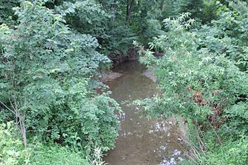
McKee Run in the summertime
|
|
| Other name(s) | McKee Creek |
| Physical characteristics | |
| Main source | valley in Anthony Township, Montour County, Pennsylvania between 940 and 960 feet (287 and 293 m) |
| River mouth | County Line Branch in Anthony Township, Montour County, Pennsylvania 525 ft (160 m) 41°05′19″N 76°42′06″W / 41.0887°N 76.7017°W |
| Length | 4.1 mi (6.6 km) |
| Basin features | |
| Progression | County Line Branch → West Branch Chillisquaque Creek → Chillisquaque Creek → West Branch Susquehanna River → Susquehanna River |
| Basin size | 2.68 sq mi (6.9 km2) |
| Tributaries |
|
McKee Run (also known as McKee Creek) is a small stream in Montour County, Pennsylvania. It's like a mini-river that flows into a bigger stream called County Line Branch. McKee Run is about 4.1 miles (6.6 km) long. It travels through an area called Anthony Township.
The land area that drains water into McKee Run is called its watershed. This watershed covers about 2.68 square miles (6.9 km2). Some parts of the stream are affected by farming activities. This means things like dirt (silt) and missing plants can impact the water.
Contents
Where Does McKee Run Flow?
McKee Run starts in a valley in Anthony Township. It flows south for a while. Then it turns southwest for a bit. After that, it turns south again. The stream crosses a road called Pennsylvania Route 44. Along its journey, it picks up water from two smaller streams. These are called unnamed tributaries because they don't have official names.
Finally, McKee Run reaches its end. It joins County Line Branch. This meeting point is about 2.40 miles (3.86 km) before County Line Branch itself ends.
McKee Run's Tributaries
McKee Run does not have any named tributaries. However, it has two smaller streams that flow into it. These are simply called UNT 18829 and UNT 18830.
Water Quality of McKee Run
The watershed of McKee Run has about 5.84 miles (9.40 km) of streams in total. All of these streams are affected by farming. This can cause dirt (siltation) to build up. It can also lead to plants being removed near the stream. Even with these challenges, the stream generally has good water quality.
Land and Features Around McKee Run
The land around McKee Run is made up of rolling hills. You can see farms with crops and pastures where animals graze. There are also forested mountains. The stream's channel, which is like its path, can be between 8 feet (2.4 m) and 18 feet (5.5 m) wide. In some spots, the banks of the stream are about 3 feet (0.91 m) high.
The highest point where the stream starts is between 940 and 960 feet (290 and 290 m) above sea level. Where it joins County Line Branch, the elevation is about 525 feet (160 m) above sea level.
The McKee Run Watershed
The watershed of McKee Run is the entire area of land that collects water for the stream. It covers about 2.68 square miles (6.9 km2). A part of this watershed, about 1.30 square miles (3.4 km2), drains into the stream before it reaches Pennsylvania Route 44. This area has an irregular shape.
The main ways people use the land in the watershed are for forests, cropland, and pasture. About 6 percent of this area is covered by forests. The stream's mouth is in the Washingtonville area. Its source is in the Hugesville area. The entire watershed is in the northern part of Montour County.
History of McKee Run
McKee Run was officially added to the Geographic Names Information System on August 2, 1979. This system keeps track of names for places like streams. Its special ID number is 1180740. People also know this stream as McKee Creek.
A concrete bridge was built over McKee Run in 1913. This bridge carries State Route 1006. It is 40.0 feet (12.2 m) long. Another bridge that carries Pennsylvania Route 44 also crosses the stream.
In 1979, there was a plan to build a reservoir (a man-made lake) on McKee Run. It would have been located about 1,500 feet (460 m) upstream from Pennsylvania Route 44. The dam for this reservoir would have been 29 feet (8.8 m) high. If built, the reservoir would have held a lot of water, about 1,063 acre-feet (1.3 million cubic meters).
Plants Along McKee Run
The plants growing along the banks of McKee Run are mostly grasses in some areas. Adding more plants and trees along the stream banks would be helpful. These plants, called riparian buffers, help keep the stream healthy.
 | Claudette Colvin |
 | Myrlie Evers-Williams |
 | Alberta Odell Jones |

