McKinley River facts for kids
Quick facts for kids McKinley River |
|
|---|---|

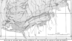
Kantishna Region Geologic map showing the location of the Muldrow Glacier origin of the river
|
|
|
Location of the mouth of the McKinley River in Alaska
|
|
| Country | United States |
| State | Alaska |
| District | Denali Borough |
| Physical characteristics | |
| Main source | Muldrow Glacier Denali National Park and Preserve 3,117 ft (950 m) 63°21′51″N 150°25′59″W / 63.36417°N 150.43306°W |
| River mouth | Kantishna River confluence with Birch Creek, 23 miles (37 km) east of Lake Minchumina 646 ft (197 m) 63°51′59″N 151°33′20″W / 63.86639°N 151.55556°W |
| Length | 58 mi (93 km) |
The McKinley River (also called Henteel no' Tl'o by some native people) is a river in central Alaska, United States. It is about 58 miles (93 kilometers) long. This river is a branch, or tributary, of the Kantishna River. It helps drain water from the northern part of the Alaska Range. This area is southwest of Fairbanks.
Journey of the McKinley River
The McKinley River begins at the Muldrow Glacier. This glacier is in the northern Alaska Range. It is located inside Denali National Park and Preserve. This park is famous for Denali, North America's tallest mountain.
From its start, the river flows mostly northwest. It travels through the open, treeless land called tundra. This tundra is north of the Alaska Range. Eventually, the McKinley River meets up with Birch Creek. Together, they form the larger Kantishna River. This meeting point is close to Chilchukabena Lake.
How the River Got its Name
The river got its name, McKinley Fork, in 1905. It was named by a person named A.H. Brooks. Other names for the river include Henteeth No' Tl'o and Hintusno' Dikats. These names come from local native languages.
 | Frances Mary Albrier |
 | Whitney Young |
 | Muhammad Ali |


