Meirionnydd facts for kids
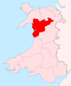
Meirionnydd is a beautiful area in Wales with a coast and mountains. Over time, it has been known by different names and had different roles, like a kingdom, a special area called a 'cantref', a county, and a district.
Contents
Meirionnydd as a Kingdom
Meirionnydd means 'Land adjoined to Meirion'. It was once a smaller kingdom within the larger Kingdom of Gwynedd. Legend says it was started by a prince named Meirion. He was the grandson of Cunedda, a brave warrior who came to Wales from the 'Old North' (which is now parts of northern England and southern Scotland) around the 400s. Meirion's family ruled this area for about 400 years. The kingdom was located between the River Mawddach and the River Dovey, stretching towards the northeast.
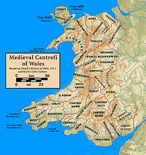
Meirionnydd as a Cantref
A 'cantref' was an old Welsh land division, like a large county. The ancient name for this cantref was Cantref Orddwy, which means "the cantref of the Ordovices" (an old tribe). However, it became known as Meirionnydd because of Meirion's kingdom.
The cantref of Meirionnydd kept the same borders as the earlier kingdom. It was now a part of the Kingdom of Gwynedd, but it often had a lot of independence. It was split into two smaller areas called 'commotes': Ystumanner and Talybont.
In 1284, the cantref system was mostly ended after the Statute of Rhuddlan. The area was then reorganized and combined with nearby cantrefi to form the county of Merioneth.
Meirionnydd as a County
The area of Meirionnydd grew when it became a county under the Statute of Rhuddlan. It gained the old cantrefi of Penllyn and Ardudwy. The name for the county was changed to the English version, "Merioneth," and sometimes called "Merionethshire."
Merioneth became an official administrative county in 1889. This meant it had an elected council to manage local affairs. In 1974, this administrative county was abolished. Most of its area joined with Caernarfonshire and Anglesey to create a new, larger county called Gwynedd.
Meirionnydd as a District
| Meirionnydd | |
| Geography | |
| HQ | Dolgellau |
| History | |
| Created | 1 April 1974 |
| Abolished | 31 March 1996 |
| Succeeded by | Gwynedd |
Quick facts for kids Demography |
|
|---|---|
| 1971 population | 29,531 |
| 1992 (estimate) population | 32,900 |
In 1974, Wales changed its local government system. It created a two-level system with larger county councils and smaller district councils. The new county of Gwynedd was divided into five districts. One of these was named "Meirionnydd," going back to the Welsh spelling.
The Meirionnydd district covered almost the same area as the old Merioneth county. It replaced eight smaller districts that existed before 1974. These included:
- Bala Urban District
- Barmouth Urban District
- Deudraeth Rural District
- Dolgellau Rural District
- Dolgellau Urban District
- Ffestiniog Urban District
- Penllyn Rural District
- Tywyn Urban District
In 1994, another law changed the local government system again. The old two-level system was replaced with new "principal areas." The Meirionnydd area joined with the nearby Arfon and Dwyfor districts to form a new county. The government first named this "Caernarfonshire and Merionethshire." However, the local council asked for a different name, and it became "Gwynedd" on April 2, 1996.
Since 1996, Gwynedd Council still uses the former Meirionnydd district as a special area for discussing local issues.
Political Control of the District
The first election for the Meirionnydd District Council was held in 1973. This council officially started its work on April 1, 1974. For its entire existence, most of the council seats were held by independent members. This means they didn't belong to a specific political party.
| Party in control | Years | |
|---|---|---|
| Independent | 1974–1996 | |
District Council Building
The district council's main office was at Cae Penarlâg in Dolgellau. This building was originally built in 1953 for the old Merioneth County Council. Since 1996, it has been used as a local office for Gwynedd Council.


