Merryville, Louisiana facts for kids
Quick facts for kids
Merryville, Louisiana
|
|
|---|---|
|
Town
|
|

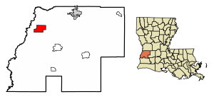
Location of Merryville in Beauregard Parish, Louisiana.
|
|

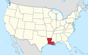
Location of Louisiana in the United States
|
|
| Country | United States |
| State | Louisiana |
| Parish | Beauregard |
| Area | |
| • Total | 9.81 sq mi (25.40 km2) |
| • Land | 9.79 sq mi (25.35 km2) |
| • Water | 0.02 sq mi (0.05 km2) |
| Elevation | 82 ft (25 m) |
| Population
(2020)
|
|
| • Total | 967 |
| • Density | 98.78/sq mi (38.14/km2) |
| Time zone | UTC-6 (CST) |
| • Summer (DST) | UTC-5 (CDT) |
| ZIP code |
70653
|
| Area code(s) | 337 |
| FIPS code | 22-50010 |
Merryville is a small town located in Beauregard Parish, Louisiana, in the United States. In 2010, about 1,103 people lived there. It's part of the wider area around DeRidder.
Contents
Exploring Merryville's Location
Merryville is found at specific coordinates: 30°45′14″N 93°32′13″W / 30.75389°N 93.53694°W. A main road, U.S. Route 190, goes through the town. This road leads about 19 miles (31 km) northeast to DeRidder, which is the main city of the parish. If you go west on the same road, you'll reach Newton, Texas, about 18 miles (29 km) away.
The Sabine River is an important natural border. It separates Texas and Louisiana. This river is only about 4 miles (6.4 km) west of the center of Merryville. The town covers a total area of about 9.81 square miles (25.4 square kilometers).
Understanding Merryville's Population
This section tells us about the people who live in Merryville. It shows how the number of people has changed over many years.
| Historical population | |||
|---|---|---|---|
| Census | Pop. | %± | |
| 1920 | 2,963 | — | |
| 1930 | 2,626 | −11.4% | |
| 1940 | 1,216 | −53.7% | |
| 1950 | 1,383 | 13.7% | |
| 1960 | 1,232 | −10.9% | |
| 1970 | 1,286 | 4.4% | |
| 1980 | 1,286 | 0.0% | |
| 1990 | 1,235 | −4.0% | |
| 2000 | 1,126 | −8.8% | |
| 2010 | 1,103 | −2.0% | |
| 2020 | 967 | −12.3% | |
| U.S. Decennial Census | |||
Population Changes Over Time
In 2000, there were 1,126 people living in Merryville. These people lived in 418 households, with 300 of them being families. The population density was about 138 people per square mile (53 people per square kilometer). There were also 482 housing units, which are places where people can live.
Who Lives in Merryville?
The people living in Merryville come from different backgrounds. In 2000, most residents were White (82.06%). About 15.19% were African American, and 1.24% were Native American. A small number were Asian (0.09%) or from other backgrounds. About 3.46% of the population identified as Hispanic or Latino.
Families and Age Groups
Many households in Merryville have children. In 2000, about 34.9% of households had children under 18 living with them. More than half (50.2%) were married couples living together.
The age of people in Merryville varies. About 28.0% of the population was under 18 years old. Around 16.4% were 65 years or older. The average age in the town was 36 years old.
Income and Economy
In 2000, the average income for a household in Merryville was $22,500 per year. For families, the average income was $30,962. The income per person in the town was $14,055.
Some families and people in Merryville lived below the poverty line. This included about 24.8% of families and 28.3% of all residents.
Well-Known People from Merryville
Some notable people have come from Merryville:
- Jesse Knowles
- Sam H. Jones
- Red Cagle
- Gussie Loftin Townsley, primitive folk artist
- Lether Frazar
See also
 In Spanish: Merryville para niños

