Mesa del Caballo, Arizona facts for kids
Quick facts for kids
Mesa del Caballo, Arizona
|
|
|---|---|

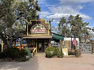
Houston Mesa General Store at the intersection of Deadeye Road and Houston Mesa Road
|
|
| Country | United States |
| State | Arizona |
| County | Gila |
| Area | |
| • Total | 0.32 sq mi (0.82 km2) |
| • Land | 0.32 sq mi (0.82 km2) |
| • Water | 0.00 sq mi (0.00 km2) |
| Elevation | 5,170 ft (1,580 m) |
| Population
(2020)
|
|
| • Total | 781 |
| • Density | 2,455.97/sq mi (947.00/km2) |
| Time zone | UTC-7 (MST (no DST)) |
| ZIP code |
85541
|
| Area code(s) | 928 |
| FIPS code | 04-46005 |
| GNIS feature ID | 40822 |
Mesa del Caballo is a small community in Gila County, Arizona, United States. It is known as a census-designated place (CDP). A CDP is a special area that looks like a town but doesn't have its own local government. It is set up by the United States Census Bureau just for counting people.
As of the 2020 census, about 781 people lived in Mesa del Caballo.
Where is Mesa del Caballo?
Mesa del Caballo is located in the northern part of Gila County. It sits on top of a low ridge called Houston Mesa. This ridge is just north of a larger town called Payson.
To get to Payson from Mesa del Caballo, you would travel about 5 miles (8 kilometers) south. You can use Houston Mesa Road and Arizona State Route 87 to make this trip. The area of Mesa del Caballo is about 0.32 square miles (0.82 square kilometers), and it's all land.
Getting Around Mesa del Caballo
Even though Mesa del Caballo is a small community, there are ways to get around. The Payson Senior Center helps run a bus service called the Beeline Bus. This bus connects Mesa del Caballo with Payson. It helps people travel between the two places.
Who Lives Here?
The number of people living in Mesa del Caballo is counted by the U.S. Census Bureau. This count helps us understand the population of the area.
- In 2010, the population was 765 people.
- By 2020, the population had grown slightly to 781 people.
See also
 In Spanish: Mesa del Caballo para niños
 | Audre Lorde |
 | John Berry Meachum |
 | Ferdinand Lee Barnett |


