Mesilla Diversion Dam facts for kids
Quick facts for kids Mesilla Diversion Dam |
|
|---|---|

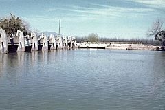
Mesilla Diversion Dam, upstream side. The headworks of one of the canals are visible in the center
|
|
|
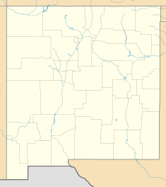
Location of Mesilla Diversion Dam in New Mexico#USA
|
|
| Country | United States |
| Location | Doña Ana County, New Mexico |
| Coordinates | 32°13′41″N 106°47′54″W / 32.227918°N 106.798308°W |
| Purpose | Irrigation |
| Owner(s) | United States Bureau of Reclamation |
| Dam and spillways | |
| Type of dam | Diversion dam |
| Height | 22 feet (6.7 m) |
| Elevation at crest | 3,819 feet (1,164 m) |
| Width (crest) | 303 feet (92 m) |
| Spillways | 3 |
The Mesilla Diversion Dam is an important structure on the Rio Grande river. It's located about 40 miles (64 km) north of El Paso, Texas. It's also about 6 miles (9.7 km) south of Las Cruces, New Mexico. This dam helps move water from the river. The water then goes into canals for irrigation. This means it helps water farms in the lower Mesilla Valley. The United States Bureau of Reclamation built and owns the dam. The Elephant Butte Irrigation District operates it.
How the Mesilla Dam Helps Farmers
Farmers in the Mesilla Valley have used river water for a long time. The first small canals were dug in 1841. More canals were added after 1848. This was when Mexico gave the region to the United States. By 1897, there were five main canals. These canals were all north of Chamberino.
Before the Mesilla Dam, the river's water flow was hard to predict. Sometimes the river would dry up for months. In 1908, the Leasburg Diversion Dam was finished. But the water flow was still not steady. Things changed when the Elephant Butte Dam was completed in 1915. This larger dam helped control the river's flow.
The Mesilla Diversion Dam was finished in 1916. By this time, the canal system could serve the entire valley. It made sure farms had enough water.
Understanding the Dam's Structure
The Mesilla Diversion Dam was built as part of the Rio Grande Project. This was a big plan to manage the river's water. The dam was completed in 1916. In 1940, its top was raised by about 1.66 feet (0.51 meters). The top of the dam is 3,819 feet (1,164 meters) above sea level.
The dam is a low concrete wall with special gates. These gates are called radial gates. They help control the water flow. The dam is about 22 feet (6.7 meters) tall. The top of the dam is about 303 feet (92 meters) long.
The dam has two main spillways. Spillways are like big drains that let extra water through.
- The west side spillway has nine radial gates. Each gate is about 21.58 feet (6.58 meters) wide and 6 feet (1.8 meters) tall.
- The east side spillway has four radial gates. Each of these gates is about 21.58 feet (6.58 meters) wide and 8.42 feet (2.57 meters) tall.
The main spillway can handle a lot of water. It can release up to 715,000 cubic feet (20,247 cubic meters) of water per second.
How Water Reaches the Farms: Canals
The Mesilla Dam sends water into two main canals. These are the East Side Canal and the West Side Canal. They bring water to about 53,650 acres (21,711 hectares) of farmland. This land is in the lower Mesilla Valley.
- The East Side Canal is about 13.5 miles (21.7 km) long. It can carry up to 300 cubic feet (8.5 cubic meters) of water per second.
- The West Side Canal is larger. It is about 23.4 miles (37.7 km) long. It can carry up to 650 cubic feet (18.4 cubic meters) of water per second.
Near its end, the West Side Canal goes under the Rio Grande river. It does this using a special tunnel called the Montoya Siphon.
 | Percy Lavon Julian |
 | Katherine Johnson |
 | George Washington Carver |
 | Annie Easley |


