Michigantown, Indiana facts for kids
Quick facts for kids
Michigantown, Indiana
|
|
|---|---|

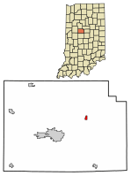
Location of Michigantown in Clinton County, Indiana.
|
|
| Country | United States |
| State | Indiana |
| County | Clinton |
| Township | Michigan |
| Founded | 1830 |
| Area | |
| • Total | 0.27 sq mi (0.70 km2) |
| • Land | 0.27 sq mi (0.70 km2) |
| • Water | 0.00 sq mi (0.00 km2) |
| Elevation | 873 ft (266 m) |
| Population
(2020)
|
|
| • Total | 441 |
| • Density | 1,627.31/sq mi (628.50/km2) |
| Time zone | UTC-5 (Eastern (EST)) |
| • Summer (DST) | UTC-4 (EDT) |
| ZIP code |
46057
|
| Area code(s) | 765 |
| FIPS code | 18-48816 |
| GNIS feature ID | 2396757 |
Michigantown is a small town in Indiana, United States. It is located in Clinton County, within Michigan Township. The town was named after the Michigan Road. This was an important early road that passed through the area. In 2020, about 441 people lived in Michigantown.
Contents
Michigantown's Story
Michigantown was first planned in 1830. Two people named Joseph Hill and Robert Edwards laid out the town. They created lots for homes and businesses on both sides of the Michigan Road. Later, in 1874 and 1876, William Lowden added more lots. These new areas extended the town north. They reached what was then the Frankfort and Kokomo Railroad line. This railroad later became the Toledo, St. Louis and Western.
In 1912, another railroad was built. The Marion, Kokomo and Frankfort Electric Railroad added a line. It ran right next to the other railroad through town. Michigantown officially became an incorporated town in the early 1870s. This means it gained its own local government.
Where Michigantown Is Located
Michigantown is a small place. It covers about 0.70 square kilometers (0.27 square miles) of land. There is no water area within the town limits. A Norfolk Southern Railway line crosses the northern part of town. This railway connects the cities of Frankfort and Kokomo.
Who Lives in Michigantown
| Historical population | |||
|---|---|---|---|
| Census | Pop. | %± | |
| 1850 | 148 | — | |
| 1870 | 315 | — | |
| 1880 | 342 | 8.6% | |
| 1890 | 298 | −12.9% | |
| 1900 | 417 | 39.9% | |
| 1910 | 395 | −5.3% | |
| 1920 | 430 | 8.9% | |
| 1930 | 419 | −2.6% | |
| 1940 | 417 | −0.5% | |
| 1950 | 443 | 6.2% | |
| 1960 | 513 | 15.8% | |
| 1970 | 457 | −10.9% | |
| 1980 | 453 | −0.9% | |
| 1990 | 472 | 4.2% | |
| 2000 | 406 | −14.0% | |
| 2010 | 467 | 15.0% | |
| 2020 | 441 | −5.6% | |
| U.S. Decennial Census | |||
Population in 2010
According to the census from 2010, 467 people lived in Michigantown. There were 183 households and 134 families. The town had about 1,796 people per square mile (693 people per square kilometer). There were 205 housing units in total.
Most of the people in town were White (97.9%). A small number were African American (0.4%) or Asian (0.4%). Some people (0.9%) were from two or more races. About 2.6% of the population identified as Hispanic or Latino.
Many households (37.7%) had children under 18 living with them. More than half (51.9%) were married couples. About 21.9% of all households were made up of people living alone. Of these, 11.5% were people aged 65 or older. The average household had 2.55 people. The average family had 2.93 people.
The average age of people in Michigantown was 34.1 years. About 27% of residents were under 18 years old. About 13.7% were 65 years or older. The town had slightly more females (52.0%) than males (48.0%).
See also
 In Spanish: Michigantown (Indiana) para niños

