
Michigan Road facts for kids
The Michigan Road was one of the first important roads built in Indiana. Back then, many "roads" were just rough paths, full of bumps and holes. But leaders in Indiana knew that good roads were super important for the state to grow and for businesses to do well. They wanted roads like the National Road, which was helping the whole country. So, they started planning and funding new roads.
Contents
History of the Michigan Road
Building the Michigan Road
The Michigan Road was like Indiana's first "super highway"! It was built in the 1830s and 1840s. This road stretched all the way from Madison in the south to Michigan City in the north, passing through Indianapolis.
Just like the National Road, the Michigan Road helped many people move into Indiana. It also helped the state's economy grow. About half of the early settlers in northwestern Indiana used this road. They traveled from the Ohio River to reach their new homes. It was the biggest project to connect Indianapolis with other parts of the state.
How the Road Was Made Possible
One big reason the road could be built was a special agreement. The state of Indiana made a treaty with the Potawatomi people on October 16, 1826. The governor at the time, James B. Ray, led these talks.
The treaty allowed Indiana to build a strip of land about 100 feet wide. This strip would go from the Ohio River (at Madison) all the way to Lake Michigan (at Michigan City). Sadly, the Potawatomi people later had to leave the area. Many of them traveled on this very road during the 1838 Potawatomi Trail of Death.
Choosing the Road's Path
In 1828, a group of people was chosen to plan the road's path. They had to figure out the best way to get from Indianapolis to Lake Michigan. They were told to find the best natural harbor on Lake Michigan for the road to end.
Building the road through the Kankakee River's swampy area was a big problem. Because of this, the planners had to change their route. Instead of going straight northwest, the road went from Logansport straight north to the south bend of the St. Joseph River. This area is now the city of South Bend. From there, it went west to Lake Michigan. Michigan City was officially chosen as the end point in 1832.
The part of the road from Madison to Indianapolis was much straighter. It went north through Ripley and Jefferson counties to Napoleon. From Napoleon, it went straight through Shelby County to Indianapolis.
Road Improvements and Challenges
The Michigan Road became the favorite way to get to Indianapolis for many counties. Even though the road only went through 14 counties, it helped 34 different counties.
In 1836, the Indiana General Assembly passed a big law called the Indiana Mammoth Internal Improvement Act. This law set aside money to pave the entire Michigan Road. However, the state soon faced money problems. This was partly due to spending too much and a financial crisis called the Panic of 1837.
Because of these problems, Indiana couldn't afford to finish paving the road. The state had to give control of the road to the individual counties. This was part of a plan to avoid losing the road to the state's lenders.
The Michigan Road Today
Today, parts of the original Michigan Road are still used, but they have different names.
- State Road 29 used to follow the route from Madison to Bryantsburg. It also followed the road from Napoleon north to Logansport.
- State Road 25 follows the old route to Rochester.
- U.S. Route 31 follows the original path from Rochester to South Bend.
- State Road 2 and U.S. Route 20 follow the original road from South Bend to Michigan City.
Some parts of the original road have been changed or replaced. For example, U.S. Route 421 now covers much of the old State Road 29 route from Madison. Also, when Interstate 465 was built, the path for US 421 changed a bit.
In Indianapolis, you can still find some reminders of the Michigan Road. A tollhouse stands just north of the White River. This building was put up by a company that repaired the road. They collected tolls (money) there to cover their costs.
There's also a monument in downtown Indianapolis. It marks where the Michigan Road and the National Road once crossed. You can find it at the corner of Washington Street and Southeastern Avenue. The monument was moved a little in 2008 when changes were made to the Interstate 65 exits.
Images for kids
-
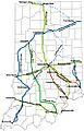
Michigan Road, as well as other early roads, in Indiana
-
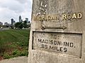
An obelisk monument near the historic intersection of the Michigan and National roads in Indianapolis
-

The former tollhouse erected by the Augusta Gravel Road Company along the road in Indianapolis


