
Middle East, Baltimore facts for kids
Quick facts for kids
Middle East, Baltimore
|
|
|---|---|
|
Neighborhood of Baltimore
|
|

Row homes in Middle East, June 2014.
|
|

Middle East, Baltimore
Location in Baltimore
|
|
| Country | |
| State | Maryland |
| City | Baltimore |
| ZIP Code |
21205
|
| Area code(s) | 410, 443, and 667 |
Middle East is a neighborhood in East Baltimore, Maryland. It's a place with a rich history and many changes.
This area is close to the famous Johns Hopkins Medical Center. The neighborhood has seen many changes over the years. It has also been a filming spot for TV shows like The Wire and Homicide: Life on the Street. Local people sometimes call parts of this area "Down the Hill."
Contents
Exploring Middle East's Past
Early Days and "Little Bohemia"
Long ago, the Middle East neighborhood was home to many Czech-American families. They were mostly working-class people. This area was even known as "Little Bohemia" because of them.
A special church called St. Wenceslaus Church was built here. It was a big part of the Czech community.
Changes in the Community
Over time, more African-American families moved into the neighborhood. By the 1970s and 1980s, the community became mostly African-American. Many Czech-Americans moved to other areas.
The name "Middle East" was given to the neighborhood in 1978. At that time, residents asked the city for help. Many homes needed repairs. The city provided money to help fix up the area.
Modern Changes and Development
Today, big changes are happening in Middle East. Johns Hopkins is expanding its campus. New buildings are being constructed for medical and science research. This project is called the East Baltimore Development Initiative (EBDI).
This development has meant that some families have had to move. New schools, shops, and parks are being built. The goal is to create a mixed-income community. This means people with different incomes will live there.
Where is Middle East Located?
Middle East is in East Baltimore. It has clear borders:
- North: East Biddle Street
- West: North Broadway
- East: Bradford Street
- South: East Fayette Street
It is surrounded by other Baltimore neighborhoods. These include Oliver, Broadway East, and Butchers Hill.
Who Lives in Middle East?
Based on the 2010 census, about 5,352 people lived in Middle East.
- Most residents (87.5%) were African American.
- About 4.9% were White.
- Around 5.9% were Hispanic or Latino.
Many people in the neighborhood work. Some homes are owned by the people who live in them.
Northeast Market: A Local Landmark
Northeast Market is an important place in Middle East. It was first built in 1885. This market has been a central spot for shopping in Baltimore for a long time.
The market has been updated a few times. In 2013, it received over two million dollars for renovations. It continues to serve the community.
Images for kids
-
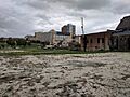
An empty field near Johns Hopkins, May 2019. This area once had row homes.
-
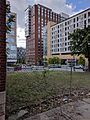
The former site of a church, May 2019. The building was removed for future medical facilities.
-
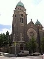
St. Wenceslaus, June 2014.
-

New Pilgrim Baptist Church, May 2019.


