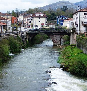
Miera River facts for kids
Quick facts for kids Miera River |
|
|---|---|
 |
|
| Country | Spain |
| Autonomous community | Cantabria |
| Physical characteristics | |
| Main source | Castro Valnera |
| River mouth | Cantabrian Sea 0 m (0 ft) |
| Length | 57 km (35 mi) |
| Basin features | |
| Basin size | 295 km2 (114 sq mi) |
The Miera River (called Río Miera in Spanish) is a river found in Cantabria, a region in northern Spain. It starts high up in the mountains and flows all the way to the Cantabrian Sea.
This river is an important part of the landscape in Cantabria. It helps shape the land and supports local ecosystems.
Where the Miera River Flows
The Miera River begins its journey in an area called Los Villares. This spot is located in Castro Valnera, a mountain at 1280 meters (about 4,200 feet) high. From there, the river flows downhill.
It travels about 57 kilometers (35 miles) before reaching the sea. The river ends its journey in the Cantabrian Sea. It joins the sea through a special area called the Cubas estuary.
Journey Through the Valley
As the Miera River flows, it passes through a narrow area known as the Miera Valley. The valley is actually named after the river itself! The river carves its way through this valley.
Eventually, the river reaches a town called Solares. After Solares, the valley opens up and becomes wider. The Miera River then forms a natural border. It separates the towns of Marina de Cudeyo and Ribamontán al Monte.
Finally, the river reaches the sea. Its waters flow into Santander Bay through the Cubas estuary.
What's in a Name?
The name "Miera" likely comes from older names. Historians believe it might be from "Magrada" or "Mégrada." These names were mentioned by a writer named Pomponius Mela way back in the 1st century.
See also
 In Spanish: Río Miera para niños
 | Victor J. Glover |
 | Yvonne Cagle |
 | Jeanette Epps |
 | Bernard A. Harris Jr. |

