

- This page was last modified on 17 October 2025, at 11:18. Suggest an edit.
Millers Point & Dawes Point Village Precinct facts for kids
| Millers Point & Dawes Point Village Precinct | |
|---|---|
Observatory_Hill_Sydney.jpg)
The Sydney Observatory, as viewed from Dawes Point
|
|
| Location | Upper Fort Street, Millers Point, City of Sydney, New South Wales, Australia |
| Built | 1788– |
| Official name: Millers Point & Dawes Point Village Precinct; Millers Point; Goodye; Leightons Point; Jack the Millers Point; Dawes Point; Tar-ra; Parish St Philip; Flagstaff Hill; Cockle Bay Point; the Point; Fort Street | |
| Type | state heritage (conservation area) |
| Designated | 28 November 2003 |
| Reference no. | 1682 |
| Type | Townscape |
| Category | Urban Area |
| Lua error in Module:Location_map at line 420: attempt to index field 'wikibase' (a nil value). | |
The Millers Point & Dawes Point Village Precinct is a special historic area in Sydney, Australia. It includes shops, offices, and homes. This area is located on Upper Fort Street in the suburbs of Millers Point and Dawes Point.
People started building here in 1788. This precinct is also known by many other names. These include Goodye, Tar-ra, and Flagstaff Hill. It was officially added to the New South Wales State Heritage Register in 2003. This means it is protected for its historical importance.
Contents
A Look Back: History of the Precinct
First People: Aboriginal Custodianship
Before Europeans arrived, the Cadigal people lived in the Millers Point area. They were the traditional owners of this land. They fished, hunted, and collected shellfish. They left piles of shells called "middens." Early Europeans later used these shells for building.
The Cadigal people called Millers Point "Coodye." They called Dawes Point "Tar-ra" or "Tarra." After Europeans settled, many Cadigal people became sick. Diseases like smallpox greatly reduced their population. They also lost their land and food sources.
Early European Settlement
When the first settlers arrived in Sydney Cove in 1788, it was hard to explore Millers Point. The area had steep, rocky hills. They focused on building homes and finding fresh water first.
In July 1788, a flag was put up on a high hill. This gave it the name Flagstaff Hill. Later, it became Observatory Hill. The first buildings here were for military or farming needs.
The first government windmill was built in 1797. This gave the area another name: Windmill Hill. More windmills were built later. One famous miller, Jack Leighton, gave his name to Millers Point.
For defense, Fort Phillip was built in 1804. Its foundations were later used for the Sydney Observatory. A military hospital was built nearby in 1815. An observatory and battery were also built at Dawes Point by William Dawes.
Growing the Economy and Shipping
More homes and businesses quickly appeared. Quarrying, or cutting stone, became a big industry. Stone from Millers Point was used to build early Sydney. This changed the landscape over time.
Another industry was making lime for building. They used shells from Aboriginal middens. When local shells ran out, they brought more from other parts of Sydney.
Millers Point was perfect for shipping because it was on the waterfront. Merchants built private jetties and warehouses. By the 1830s, Millers Point became a busy village. It was a hub for trade and related businesses.
People could reach Millers Point by rough steps from The Rocks. Successful wharf owners, workers, and craftspeople lived here. Land ownership was a bit messy at first. Later, a Commissioner of Claims helped sort out land grants.
The village became vital for coastal and international trade. Shipping, shipbuilding, and other activities grew. This made Millers Point known for its maritime industries. Wealthy merchants built grand homes. Some streets, like Argyle and Lower Fort Streets, were called 'Quality Row.'
Workers needed to live close to the wharves. Ships arrived at all hours, and goods like wool had to be loaded quickly. This meant workers needed to be on call. The community had many people who moved around a lot.
Millers Point became a self-contained village by the 1840s. It was a multicultural place with sailors and merchants from all over. It had shops, churches, and schools. St Brigid's Church and school opened in 1835. The Anglican Garrison Church was built in 1840.
Many hotels were also popular gathering spots. The Lord Nelson and Hero of Waterloo hotels are still open today. These old hotel buildings show how important they were to the area's social and economic life.
Connecting Millers Point to the rest of Sydney was a big goal. In 1843, work began on the Argyle Cut. This was a passage cut through the rock. Convicts first worked on it, then the City Council finished it. The sandstone from the cut was used in local buildings.
Even with better access, Millers Point kept its unique feel. By the mid-1800s, it was a thriving community. It had different churches, shops, and services. In 1850, the Fort Street Model School opened. This showed Millers Point was a successful area. It also showed how old buildings could be used for new purposes.
The discovery of gold in Bathurst briefly caused a worker shortage. But soon, more immigrants arrived in New South Wales. This led to a boom in the 1850s. Exports, especially wool, increased greatly.
By the 1860s, commercial needs grew. Larger jetties and warehouses were built. Smaller industries were replaced by bigger ones. The population changed too. Many skilled workers and merchants moved away. Millers Point became a place mostly for unskilled laborers.
Late 1800s: Changes and Challenges
In the 1880s and 1890s, many good-quality Victorian homes were built. These included boarding houses for temporary stays. The Kent Street Model Lodging House was an example of new housing for those with less money.
Around 1900, a new type of brick apartment building appeared. This was due to an economic slowdown. Many workers in Millers Point relied on shift work. They struggled to earn regular wages during tough times. A big strike in 1890 also left many families with less income. International trade slowed down, and the area's prosperity faded.
The city was growing, and the government needed to step in. Roads and sewers needed fixing. Private companies owned the wharves and made big profits. But they didn't invest enough in keeping them in good shape. This led to poor conditions and health risks.
People's opinion of Millers Point also declined. It was seen as unstable and "rough." Unemployed single men were a large part of the community. They often gathered in hotels. Problems with sanitation and housing were highlighted. This added to fears of disease and crime.
The Argyle Cut became a symbol of this area's challenges. The "Millers Point Push" was a group of young people. They were often unemployed laborers, not criminals.
1900s: Plague and Government Takeover
.jpg)
A view of the Dawes Point and Millers Point precinct in 1911. It shows houses and the construction of the Munn Street bridge. The Sydney Observatory is in the background.
In January 1900, an outbreak of bubonic plague happened. This gave the government a reason to take control of the Sydney waterfront. Ship and wharf owners had ignored warnings. They threw dead rats into the harbor. This made the problem worse.
Millers Point was a high-risk area due to its link to shipping. Local and state groups argued over how to handle the situation. Wharf activities stopped, and many workers were quarantined.
The government took over large parts of the foreshore. Some people criticized this. They said the plague was just an excuse. The government wanted to redevelop and modernize shipping facilities. It also wanted to clear the way for the Sydney Harbour Bridge. This meant Dawes Battery had to be destroyed.
The Sydney Harbour Trust was set up in 1900. Its job was to modernize the waterfront. It also controlled housing in the areas it took over. Many homes, shops, and pubs were included.
Many buildings were demolished. Streets like Wentworth and Clyde were removed. Houses on Jack the Millers Point were torn down. The demolished homes were not rebuilt. This caused tension between the government and the City Council.
The Sydney Harbour Trust ended up with 803 properties. This included 401 homes. Their main goal was to redevelop the Port of Sydney. This involved fixing wharves and building new roads. Hickson Road was one result of this policy. Entire streetscapes of Millers Point were destroyed. The Walsh Bay finger wharves were also created.
Some housing for workers was built in 1908. Twenty-two flats were constructed in Dalgety Road. More homes and businesses followed between 1908 and 1915. Both old and new housing was rented to people who worked on the wharves. Millers Point became like a "company town." This meant the Trust was the main landlord and employer.
Other developments included shops and flats. The Public Works Department built 32 model houses. New worker housing mostly stopped with World War I. So, Millers Point ended up with fewer hotels, homes, and shops. Street names were changed, and Cumberland Street became York Street. This connected Millers Point more directly to the city center.
Mid-1900s: Depression and War
After World War One, trade increased. But it didn't reach pre-war levels. In the late 1920s, the port's trade decreased. Then, in 1930, the Great Depression hit. This had a huge impact on Millers Point. Few laborers were needed for cargo. Waterfront jobs were scarce until 1936.
Larger, modern ships also caused problems. They needed deeper water at the wharves. Fewer ships were needed, making wharf work irregular. Strikes and union disputes also caused tension. The Sydney Harbour Trust became the Maritime Services Board (MSB) in 1936. The Sydney Harbour Bridge, completed in 1932, changed the area's isolation. It separated the maritime area from the city center.
One good thing came from these tough times. The Millers Point community became stronger. Most residents depended on the wharves for work. They shared similar backgrounds and political views. This created a deep sense of unity. The Sydney Harbour Bridge and railway tracks also made them feel more isolated, strengthening their bond.
During World War Two, waterfront jobs improved. Social conditions got better. Residents added to their homes to deal with overcrowding. The MSB was a good landlord. They painted homes regularly.
This strong community spirit continued through the 1950s and 1960s. As people could afford homes in the suburbs, housing pressure eased. Better transport meant workers could live outside Millers Point. This briefly affected community unity.
However, this unity returned in the 1960s. Residents protested against new high-rise developments. They joined with people from The Rocks to fight these plans.
In 1958, architect John Fisher and artist Cedric Flower helped paint a bungalow. This drew attention to The Rocks' importance. Fisher then helped arrange leases for historic houses.
Late 1900s: Development and Protection
Because of these protests, development in Millers Point was limited. Some wharf structures were rebuilt in 1964. Some buildings were demolished, especially on Merriman Street. The Harbour Control Tower was built in 1974.
New high-rise buildings appeared in the 1970s and 1980s. Old buildings were also reused for businesses. The Walsh Bay wharves were redeveloped for new uses. But by the mid-1970s, less cargo was handled.
Community opposition and "Green Bans" helped pass the New South Wales Heritage Act in 1977. In the same year, Richmond Villa, a historic home, was moved to Kent Street. It became the base for the Society of Australian Genealogists. The former Fort Street School was also adapted for the National Trust and an art gallery.
In the early 1980s, the Department of Housing took over properties from the Maritime Service Board. Some residents worried about their new landlord. The Department of Housing also filled empty homes with people from outside the suburb. Critics feared this would break up the community.
Despite these changes, groups like the Millers Point Resident Action Group fought to protect the area. In 1988, the New South Wales Heritage Council recognized Millers Point as very important. In 1999, the Millers Point Conservation Area was added to the State Heritage Register. Other important buildings, like the Observatory, were also listed.
Today, the area is still mainly residential. New private housing has been built nearby. The population is growing again. This shows the suburb is being revitalized.
What the Precinct Looks Like
Millers Point is a sandstone peninsula in Sydney Harbour. It sits between Cockle Bay and Sydney Cove. Millers Point is on the northwest, and Dawes Point (Tar-ra) is on the northeast. A ridge runs north-south, dividing it from The Rocks to the east.
The streets mostly run north-south (Kent Street, High Street, Hickson Road). Smaller streets cross them. Lower Fort Street runs southwest-northeast. Windmill and Argyle streets are the main east-west streets.
The peninsula's shape is still very clear. You can see the different levels, or terraces, on its western side. These have been shaped over 200 years.
In the Millers Point area, Observatory Hill is the highest level. Below it is the wide Kent Street level. Then comes the narrow High Street level. Finally, there's the Hickson Road level, which is at the wharves. This pattern repeats in the Dawes Point area. Lower Fort Street is at the same height as Kent Street. It then drops to Pottinger Street and the Hickson Road level in Walsh Bay.
The built-up area has two main parts: Millers Point (south and west) and Dawes Point (north). Both are mostly residential. Dawes Point has larger houses and wider views of the harbor. Millers Point has smaller houses, green spaces like Observatory Park, and views into Darling Harbour and Walsh Bay.
Overall, the buildings are low-scale and line straight north-south streets. Public stairways connect the different levels. This reflects the steep, terraced land.
Current Condition
As of 2003, much of Millers Point still had high archaeological potential. This means there could be many hidden historical items underground. Areas like Observatory Hill and Fort Street School are especially important.
Millers Point is special because it has the earliest known above-ground archaeological structures from Fort Phillip. Its archaeological value is higher than other parts of Sydney's city center. This is because the area hasn't been redeveloped much in the last century.
The buildings in Millers Point are in various conditions, from excellent to fair. They show building styles from the 1820s to the 1930s. Most of these buildings remained intact after the government took over the land. Only a few newer buildings were added in the late 1900s.
The precinct clearly shows its historical importance.
Changes Over Time
- 1790s: Government windmills were built. Dawes Point fort and observatory were constructed.
- 1804: Fort Phillip was built on the peninsula's heights.
- 1820s-1880s: Urban development spread across the whole area.
- 1850s: The Fort Phillip site was adapted for the Observatory and parklands.
- 1900s: After the bubonic plague, many buildings were demolished and rebuilt. Dawes Point saw fewer changes.
- 1910s-1920s: Walsh Bay wharves were constructed.
- 1920s: The Sydney Harbour Bridge and its approaches were built.
- 1970s-1980s: Darling Harbour wharves were built. This moved the western shoreline about 200 meters west.
Several phases of development shaped Millers Point:
- 1788-1820: Early European changes to the natural environment. Quarries and roads were established.
- Around 1820-1850: The landscape changed a lot as maritime industries grew. Wharves, warehouses, and homes were built. The Argyle Cut was created.
- Around 1850-1890s: Larger commercial buildings replaced smaller ones. Homes changed from big single buildings to boarding houses. Better transport allowed owners to move to wealthier areas.
- Around 1890s-1900s: Streets were realigned and modernized. Then, in the early 1900s, the government took over many properties. The plague was used as a reason for this.
- 1905-1918: After wharves and worker housing were redeveloped, there were only occasional changes. This means the area still has intact examples of 19th and 20th-century industry and community.
- 1932: The Sydney Harbour Bridge changed the look and feel of Millers Point. It also reinforced the "village" community.
- Around 1950-1990s: Only limited changes were made to the landscape.
More Information
The local community is very important to Millers Point. Residents are dedicated to keeping the suburb's unique character. Many families have lived here for generations. They also have strong ties to the maritime industries. The history, social life, and physical buildings of Millers Point are all connected. This gives the area a very special social meaning.
Why This Place is Special: Heritage Listing
As of November 28, 2003, the Millers Point & Dawes Point Village Precinct is important to the whole state of New South Wales. It shows how colonial and post-colonial settlements developed in Sydney. You can see this in its buildings, historical layers, records, and the people who live there.
The natural rocky land is still a key part of this urban landscape. Land and water, nature and culture, are all closely linked here. This connection is seen in its history, social life, looks, and how it functions.
The strong links between the local Cadigal people and this place are still clear. This is shown in the archaeological finds, historical records, and place names. Sydney's Aboriginal communities still value this area greatly.
Many colonial-era buildings were removed after the bubonic plague in 1900. But much of that history remains. It's found in the diverse archaeology and historical records. You can also see it in the place names. Some old merchant homes and terraces still exist. The area feels like a low-rise, walking-friendly village. It has a central green space in Argyle Place. You can catch glimpses of the harbor along its streets. You can hear boats and smell the sea.
The period after colonial times is also well represented. This includes early 20th-century public housing for waterside workers. There are also innovative warehouses and the Sydney Harbour Bridge approaches. Parklands mark the edges of the precinct. The street patterns, mix of houses, shops, and pubs still show the area's connection to wharf work. The social and family histories of residents also tell this story.
Millers Point & Dawes Point Village Precinct has changed over time. This is due to its location on a peninsula. It's also shaped by bigger historical events in New South Wales since the 1780s. These include:
- The arrival of the British.
- Relationships between different cultures.
- Convict history.
- Defending Sydney.
- The growth of sea-based industries like fishing.
- Moving and storing goods for trade.
- People moving in and out of the country.
- Scientific discoveries.
- Small factories.
- Energy production.
- Economic changes.
- Disputes over waterfront work.
- The rise of trade unions.
- The development of the City of Sydney government.
- Public health, town planning, and heritage protection.
- Religious guidance.
- Inspiration for art.
- The growth of unique and self-sufficient communities.
The entire place is a living cultural landscape. Both local residents and the people of New South Wales value it greatly.
Historical Importance
Millers Point & Dawes Point Village Precinct is important to the state. It shows the development of Sydney and New South Wales. This is seen in its physical forms, historical layers, records, and social makeup.
The rocky land is still a key part of this urban landscape. Land and water, nature and culture, are closely linked here. This connection is seen in its history, social life, looks, and how it functions.
The strong links between the local Cadigal people and this place are still clear. This is shown in the archaeological finds, historical records, and place names. Sydney's Aboriginal communities still value this area greatly.
Many colonial-era buildings were removed after the bubonic plague in 1900. But much of that history remains. It's found in the diverse archaeology and historical records. You can also see it in the place names. Some old merchant homes and terraces still exist. The area feels like a low-rise, walking-friendly village. It has a central green space in Argyle Place. You can catch glimpses of the harbor along its streets. You can hear boats and smell the sea.
The period after colonial times is also well represented. This includes early 20th-century public housing for waterside workers. There are also innovative warehouses and the Sydney Harbour Bridge approaches. Parklands mark the edges of the precinct. The street patterns, mix of houses, shops, and pubs still show the area's connection to wharf work. The social and family histories of residents also tell this story.
Millers Point & Dawes Point Village Precinct has changed over time. This is due to its location on a peninsula. It's also shaped by bigger historical events in New South Wales since the 1780s. These include:
- The arrival of the British.
- Relationships between different cultures.
- Convict history.
- Defending Sydney.
- The growth of sea-based industries like fishing.
- Moving and storing goods for trade.
- People moving in and out of the country.
- Scientific discoveries.
- Small factories.
- Energy production.
- Economic changes.
- Disputes over waterfront work.
- The growth of trade unions.
- The development of the City of Sydney government.
- Public health, town planning, and heritage protection.
- Religious guidance.
- Inspiration for art.
- The growth of unique and self-sufficient communities.
The entire place is a living cultural landscape. Both local residents and the people of New South Wales value it greatly.
Connections to Important People
Millers Point & Dawes Point Village Precinct is important because it's linked to many significant people in NSW history. These include:
- The Cadigal people.
- Colbee, a Cadigal leader in the 1790s.
- Lt William Dawes, the first colonial astronomer. Dawes Point is named after him.
- Jack "the miller" Leighton, a windmill owner.
- Merchants like William Walker, Henry Moore, and Robert Towns.
- Engineer Norman Selfe.
- The Sisters of St Joseph, Catholic nuns at St Brigid's.
- The "Millers Point Push," a group of local young people.
- Ted Brady, a wharf laborer and political activist.
- Arthur Payne, the first person to get the Plague in 1900.
- William Morris Hughes, a union leader and later prime minister.
- RRP Hickson, chairman of the Sydney Harbour Trust.
- The Waterside Workers Federation (WWF), a union formed in 1902.
- Jim Healy, a long-time general secretary of the WWF.
- Harry Jensen, Lord Mayor of Sydney.
- The multi-generational "Pointer" families who give the area its special social character.
Beauty and Achievements
Millers Point & Dawes Point Village Precinct is important for its beauty and creative achievements. It's a landmark with terraced sandstone. It forms an "eastern wall" to the inner harbor. It also supports the fortress-like southern approaches to the Sydney Harbour Bridge.
It has a unique village-like feel by the harbor. You can see the central "green" in Argyle Place. There are views of the harbor along its streets and over rooftops. You can hear boats and smell the sea.
The area also shows technical innovations. The natural land was reshaped. This includes the hand-cut Argyle Cut. The western slopes were leveled and terraced. The highly planned Walsh Bay and Darling Harbour docklands were created in the 20th century.
The precinct has inspired many artists. Painters like Joseph Fowles and Sydney Long have depicted it. Photographers like Harold Cazneaux and Sam Hood captured its image. Mapmakers like Dawes and Meehan also drew it.
The whole precinct shows a range of technologies and achievements from the 1820s to the 1930s. This includes landscaping, homes, industries, public areas, warehouses, and religious buildings. Millers Point is an intact example of early 20th-century shipping facilities. It has many architectural styles that are well-preserved. Many rare shops and homes still exist. The Observatory, Fort Street School, and Holy Trinity Church are especially important. Old colonial homes, hotels, and businesses also add to its value.
It has dramatic harborside land that has been changed for human use. It offers extensive views. It is seen as a complete and unified area. This is due to its buildings, shape, and size. The Sydney Harbour Bridge, Bradfield Highway, Walsh Bay, and Darling Harbour clearly define it.
Community and Culture
Millers Point & Dawes Point Village Precinct is important for its strong connection to a community in NSW. Many current residents are descendants of earlier generations. This has created a strong sense of community and loyalty. Preserving the physical and social parts of Millers Point helps us understand inner Sydney lifestyles from the early 1900s.
After the government took over, social and public works were established. Building improvements were made as the suburb became a "company port town." The Sydney Harbour Trust built worker housing and support services. They also improved existing buildings. Today, the Department of Housing manages the area in a similar way. Parts of the area are public land, and some are privately owned.
The precinct shows evidence of educational and social improvement programs. These took place at churches and schools. St Brigid's School and the Fort Street School are examples. The Anglican Holy Trinity (Garrison) Church and the Catholic St Brigid's Church and school also played a role. They served the Irish working-class community.
Research Potential
Millers Point & Dawes Point Village Precinct is important for its potential to provide new information. This information can come from its archaeological resources. These resources are not easily found elsewhere. The buildings and archaeological sites have remained intact. This is thanks to community opposition to redevelopment. Many sites in the area are undisturbed.
The physical evidence of the area's history is supported by rich oral histories. Many current residents have stories passed down through generations. This is a rare resource. It helps us better understand Millers Point's historical role and social structures.
Unique and Rare Aspects
Millers Point & Dawes Point Village Precinct is unique. It's a rare example of a harborside area that shows over 200 years of human settlement. It covers all historical periods in Australia since 1788. Other historical maritime areas in Australia might have a mix of old and new values. But none are as old or as deeply connected to so many historical, social, aesthetic, technological, and research values. These values have shaped Australian society since 1788.
The precinct is likely unique in Australia. It has a strong sense of unity. This comes from its buildings, structures, physical features, and social elements. The original buildings are largely intact. Successive generations of residents have lived here. This creates a rare level of authenticity.
Millers Point has the earliest above-ground archaeological evidence from the colonial period. It has important structures. It also has shipping and wharf structures nearby that are believed to be internationally significant. Finally, it has rare early buildings with specific functions in Australia. Examples include the Lord Nelson Hotel and the Observatory.
Demonstrating Key Characteristics
Millers Point & Dawes Point Village Precinct shows the main features of 19th and 20th-century Australian harborside areas. These include:
- Workplaces and homes being very close.
- New ways to move goods and people between land and water.
- How natural elements (water, wind) interact with human-made structures (wharves, boatyards, warehouses).
- The constant reshaping of the shoreline. This happened to keep the area viable as a living, working place.
The precinct represents 19th and 20th-century residential and maritime environments. It has many different architectural styles and buildings. It contains good examples of Australian homes and businesses. You can see how housing developed. This ranges from early buildings to 20th-century terrace houses.
The social role of neighborhood hotels and corner shops is also clear. These were typical social spaces in the 19th century. Keeping these structures shows the "everyday" environment of Millers Point. The combination of these common buildings in a distinct space makes Millers Point a very good example of its kind.
Images for kids
-
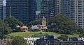
The Sydney Observatory, as viewed from Dawes Point
-
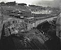
A view of the Dawes Point and Millers Point precinct in 1911, showing houses and the construction of the Munn Street bridge, with the Sydney Observatory in the background.
-
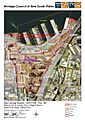
Millers Point & Dawes Point Village Precinct map