Millersburg, Indiana facts for kids
Quick facts for kids
Millersburg, Indiana
|
|
|---|---|

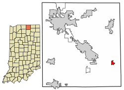
Location of Millersburg in Elkhart County, Indiana.
|
|
| Country | United States |
| State | Indiana |
| County | Elkhart |
| Township | Clinton, Benton |
| Area | |
| • Total | 0.65 sq mi (1.67 km2) |
| • Land | 0.65 sq mi (1.67 km2) |
| • Water | 0.00 sq mi (0.00 km2) |
| Elevation | 883 ft (269 m) |
| Population
(2020)
|
|
| • Total | 957 |
| • Density | 1,481.42/sq mi (572.01/km2) |
| Time zone | UTC-5 (Eastern (EST)) |
| • Summer (DST) | UTC-4 (EDT) |
| ZIP code |
46543
|
| Area code(s) | 574 |
| FIPS code | 18-49536 |
| GNIS feature ID | 2396764 |
| Website | Website |
Millersburg is a small town located in Elkhart County, Indiana, in the United States. It is part of both Clinton and Benton townships. In 2020, about 957 people lived in Millersburg. It's a quiet place with a friendly community feel.
Contents
History of Millersburg
Millersburg was officially planned and mapped out in 1855. It was named after its founder, a person named Solomon Miller. He helped start the town.
Where is Millersburg Located?
Millersburg is found at specific coordinates: 41.524866 degrees North and 85.697137 degrees West. This location helps people find it on a map.
The town covers a total area of about 0.54 square miles (1.4 square kilometers). All of this area is land, meaning there are no large lakes or rivers within the town limits.
How Many People Live in Millersburg?
| Historical population | |||
|---|---|---|---|
| Census | Pop. | %± | |
| 1870 | 52 | — | |
| 1880 | 449 | 763.5% | |
| 1890 | 394 | −12.2% | |
| 1900 | 481 | 22.1% | |
| 1910 | 428 | −11.0% | |
| 1920 | 385 | −10.0% | |
| 1930 | 344 | −10.6% | |
| 1940 | 384 | 11.6% | |
| 1950 | 437 | 13.8% | |
| 1960 | 489 | 11.9% | |
| 1970 | 618 | 26.4% | |
| 1980 | 809 | 30.9% | |
| 1990 | 854 | 5.6% | |
| 2000 | 868 | 1.6% | |
| 2010 | 903 | 4.0% | |
| 2020 | 957 | 6.0% | |
| U.S. Decennial Census | |||
Millersburg Population in 2010
According to the census from 2010, there were 903 people living in Millersburg. These people lived in 324 households, and 244 of those were families.
The town had about 1,672 people per square mile. There were 345 homes, with about 639 homes per square mile. Most of the people living in Millersburg were White (97.0%). A small number were African American (0.6%), Native American (0.9%), or from other backgrounds. About 4.4% of the population identified as Hispanic or Latino.
In 2010, 42.9% of households had children under 18. Most households (57.1%) were married couples. About 18.2% of households were single individuals. The average household had 2.79 people. The average family had 3.22 people.
The average age of people in Millersburg was 33.1 years. About 30.1% of residents were under 18. About 9.2% were 65 or older. The town had slightly more males (51.1%) than females (48.9%).
Millersburg School System
Millersburg Elementary School History
Millersburg Elementary School used to be a school for all grades, from kindergarten through 12th grade. This changed in 1968 when Fairfield Junior-Senior High School opened. After that, Millersburg became an elementary school.
Many students at Millersburg Elementary are from the Amish community. In 1999, a new school called Benton Elementary School was built. It was meant to serve students in the rural areas around New Paris and Millersburg.
In 2008, the Fairfield Community Schools board discussed the number of students. Millersburg Elementary had fewer students, while Benton Elementary was growing fast. The school board decided to expand the area Millersburg Elementary served. This was to help increase its student numbers and prevent Benton from becoming too crowded. However, this plan did not bring new students to Millersburg.
See also
 In Spanish: Millersburg (Indiana) para niños
 | Victor J. Glover |
 | Yvonne Cagle |
 | Jeanette Epps |
 | Bernard A. Harris Jr. |

