
Mills Creek (San Mateo County) facts for kids
Quick facts for kids Mills Creek |
|
|---|---|

Location of the mouth of Mills Creek in California
|
|
| Country | United States |
| State | California |
| Region | San Mateo County |
| City | Burlingame |
| Physical characteristics | |
| Main source | San Mateo County, California |
| River mouth | Burlingame, California 29 ft (8.8 m) 37°35′50″N 122°21′57″W / 37.59733°N 122.36571°W |
Mills Creek is a small stream in California, United States. It flows east through the city of Burlingame in San Mateo County. This creek starts in the hills near Mills Canyon Park and eventually empties into the San Francisco Bay.
Mills Creek is located between two other creeks. To its south is Easton Creek. To its north, you will find Millbrae Creek.
Contents
The Journey of Mills Creek
Mills Creek begins its journey in the hills of Burlingame. Its source is in and around Mills Canyon Park. This area is known for its natural beauty.
Flowing Through Burlingame
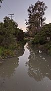
For much of its path, Mills Creek flows in a natural channel. This means it moves freely through the hills. It also flows through the flat, residential areas of Burlingame.
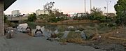
As the creek gets closer to the San Francisco Bay, things change. Near the Caltrain tracks, parts of the creek are hidden. It flows through underground pipes called culverts. Other parts are made into a straight channel. This helps guide the water into the bay.
Where the Creek Ends
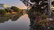
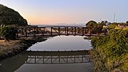
The journey of Mills Creek ends when its waters reach the San Francisco Bay. This bay is a large inlet of the Pacific Ocean. It is an important natural feature of California.
Gallery of Mills Creek
-
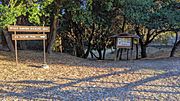
Mills Canyon Wildlife Area headwaters region
-
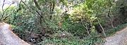
In Mills Canyon
-
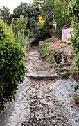
upstream of railroad tracks
-
Pano along railroad tracks (left) and Rollins Road (right)
-
At Rollins Road
-
Behind the Adrian Storm Station
-
Adrian Storm Station
-
Upstream from Old Bayshore Highway
-
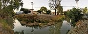
Slough entering the Bay


