
Milne Inlet facts for kids
72°15′N 080°30′W / 72.250°N 80.500°W Milne Inlet is a small, shallow arm of Eclipse Sound in Nunavut, Canada. It helps separate Bylot Island from Baffin Island. This inlet is shallow, has strong winds, and experiences high tides. It is only free of ice for about 90 days each year, usually from August to October.
The nearby community of Pond Inlet, also known as Mittimatalik, is about 80 km from Milne Inlet. Most of the people living there are Inuit. This area is part of the Arctic Cordillera, which has a very cold climate. Winters are long and dark, with average temperatures around -35°C.
A company called Baffinland Iron Mines Corporation owns the Mary River iron ore mine, which is about 100 km from Milne Inlet. In the 2000s, the company started building a harbour at Milne Inlet. This harbour began operating in 2015. Baffinland wants to increase how much iron ore they produce. They have asked to use ice-breaking ships to keep the waters open for ten months a year. This plan has caused worry among the local Inuit communities.
What is Milne Inlet?
Milne Inlet is a shallow body of water, about 80 km long. At its widest point, it is about 30 km across. It is located across from Bylot Island, on the other side of Eclipse Sound. The inlet freezes over in October and usually opens up again in August.
Eclipse Sound is part of the Tallurutiup Imanga National Marine Conservation Area. This is a large protected area that includes all the waters around Bylot Island. The conservation area covers about 108,000 square kilometers. It also includes parts of Sirmilik National Park and several bird sanctuaries.
In 2019, the Canadian government and the Qikiqtani Inuit Association (QIA) signed an agreement. This agreement was important for officially creating the Tallurutiup Imanga National Marine Conservation Area.
Life in the Arctic
Pond Inlet is the largest community in Northern Baffin Island, with about 1,617 people. Most of the people (92%) are Inuit. The region is very cold, with long, dark winters. Temperatures often average around -35°C.
The Inuit people in this area earn money from jobs. They also rely on traditional activities like hunting, fishing, trapping, and gathering food. These activities are very important to their way of life.
The Mary River Mine and Shipping
The Mary River iron ore mine is owned by Baffinland Iron Mines Corporation. It is located about 100 km from Milne Inlet. The company built a harbour at Milne Inlet to ship iron ore. For example, in 2018, ships made 71 trips from Milne Inlet. They carried large amounts of iron ore to markets in Europe and other places.
To reach the open waters of Baffin Bay, ships must travel through a 160 km channel. This channel is located between Bylot Island and Baffin Island. All the waters around Bylot Island are part of the Tallurutiup Imanga National Marine Conservation Area.
This region is known for its rich wildlife. It has many ice caps, glaciers, and mountains. It also has the largest and most diverse bird communities in the Arctic. Many marine mammals live here, including narwhal and beluga whales. Seals, walruses, and polar bears also call this area home.
Milne Inlet has two small islands. Ragged Island is located near the inlet's opening. Stephens Island is found further inside the inlet.
Images for kids
-
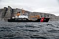
United States Coast Guard Cutter Juniper navigating through Milne Inlet in 2012

