Milstead, Georgia facts for kids
Quick facts for kids
Milstead, Georgia
|
|
|---|---|
| Country | |
| State | Georgia |
| County | Rockdale |
| Area | |
| • Total | 0.46 sq mi (1.19 km2) |
| • Land | 0.44 sq mi (1.13 km2) |
| • Water | 0.02 sq mi (0.06 km2) |
| Elevation | 800 ft (200 m) |
| Population
(2020)
|
|
| • Total | 628 |
| • Density | 1,437.07/sq mi (555.49/km2) |
| Time zone | UTC-5 (Eastern (EST)) |
| • Summer (DST) | UTC-4 (EDT) |
| ZIP Code |
30012 (Conyers)
|
| Area code(s) | 470/678/770 |
| FIPS code | 13-51660 |
| GNIS feature ID | 2806020 |
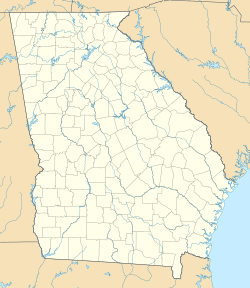
Milstead is a small place in Rockdale County, Georgia, United States. It's known as an unincorporated community. This means it's not a city or town with its own local government. It's also a census-designated place (CDP). This is a special area the government defines for counting people.
Milstead is located near the city of Conyers, which is the main town in the county. To the north, you'll find the Yellow River. In 2020, about 628 people lived in Milstead.
About the People of Milstead
| Historical population | |||
|---|---|---|---|
| Census | Pop. | %± | |
| 2020 | 628 | — | |
| U.S. Decennial Census 2020 |
|||
Milstead was first officially counted as a census-designated place in the 2020 U.S. Census.
Who Lives in Milstead?
The 2020 census showed that Milstead is home to people from many different backgrounds. Most residents are White, making up about 56% of the population. African Americans are the next largest group, at around 24%.
There are also smaller groups of Asian Americans and Native Americans. About 11% of the people living in Milstead are of Hispanic or Latino heritage. This means Milstead is a diverse community where many different cultures come together.
 | Ernest Everett Just |
 | Mary Jackson |
 | Emmett Chappelle |
 | Marie Maynard Daly |


