Mine Kill facts for kids
Quick facts for kids Mine Kill |
|
|---|---|
|
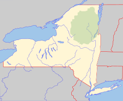
Location of mouth within New York
|
|
| Country | United States |
| State | New York |
| Physical characteristics | |
| Main source | Schoharie County, New York |
| River mouth | Schoharie Creek Gilboa, Schoharie County, New York, United States 42°25′54″N 74°27′45″W / 42.43167°N 74.46250°W |
| Basin features | |
| Basin size | 17.7 sq mi (46 km2) |
Mine Kill is a small river, also called a "kill," located in New York State. It flows into the Schoharie Creek near the town of Gilboa. The word "kill" comes from an old Dutch word for "creek" or "river."
How We Measure Mine Kill
Scientists keep a close eye on rivers like Mine Kill to understand how much water they carry. The United States Geological Survey (USGS) is a group of scientists who study the Earth, including its water.
Tracking Water Flow
The USGS has a special tool called a stream gauge on Mine Kill. This gauge is like a measuring stick for the river. It helps them know how much water is flowing at different times.
- The stream gauge is located about 0.6 miles (1 kilometer) upstream from where Mine Kill joins Schoharie Creek.
- It's also about 3 miles (5 kilometers) southwest of a place called North Blenheim.
River's Water Levels
The amount of water flowing in a river is called its discharge. This can change a lot depending on the weather, like after heavy rain or during a dry spell.
- The highest amount of water ever recorded at this gauge was 2,550 cubic feet per second. This happened on January 19, 1996.
- The lowest amount of water recorded was just 0.1 cubic feet per second. This very low flow happened between August 27 and 30, 1980.
These measurements help scientists understand the river's health and how its water levels change over time.
 | Victor J. Glover |
 | Yvonne Cagle |
 | Jeanette Epps |
 | Bernard A. Harris Jr. |


