Miraflores, Añasco, Puerto Rico facts for kids
Quick facts for kids
Miraflores
|
|
|---|---|
|
Barrio
|
|

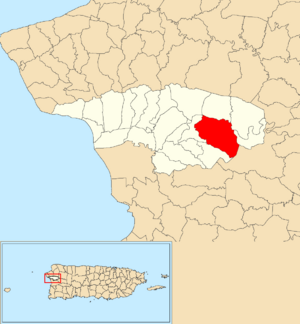
Location of Miraflores within the municipality of Añasco shown in red
|
|
| Commonwealth | |
| Municipality | |
| Area | |
| • Total | 3.71 sq mi (9.6 km2) |
| • Land | 3.65 sq mi (9.5 km2) |
| • Water | 0.06 sq mi (0.2 km2) |
| Elevation | 151 ft (46 m) |
| Population
(2010)
|
|
| • Total | 567 |
| • Density | 155.3/sq mi (60.0/km2) |
| Source: 2010 Census | |
| Time zone | UTC−4 (AST) |
Miraflores is a small community, also known as a barrio, located in the municipality of Añasco, Puerto Rico. In 2010, about 567 people lived there. It's a part of the beautiful island of Puerto Rico.
Contents
Hurricane Maria's Impact
On September 20, 2017, Hurricane Maria hit Puerto Rico very hard. Miraflores was greatly affected. The storm caused many landslides and a lot of damage. Roads, like PR-109, became blocked or destroyed. This made it impossible for people to get in or out of Miraflores.
Even five months after the hurricane, engineers and officials were still working. They faced huge repair jobs for roads in Miraflores and all of Añasco. It took a lot of effort to fix everything.
Population and Demographics
Understanding the population of a place helps us learn about its history. Demographics means studying how populations change. This includes how many people live somewhere and how that number changes over time.
Below is a table showing how Miraflores's population has changed over the years:
| Historical population | |||
|---|---|---|---|
| Census | Pop. | %± | |
| 1950 | 941 | — | |
| 1980 | 764 | — | |
| 1990 | 619 | −19.0% | |
| 2000 | 730 | 17.9% | |
| 2010 | 567 | −22.3% | |
| U.S. Decennial Census 1899 (shown as 1900) 1910-1930 1930-1950 1980-2000 2010 |
|||
As you can see, the population of Miraflores has changed quite a bit. It was highest in 1950 and has decreased since then.
Understanding Sectors
In Puerto Rico, barrios are like small districts. These barrios are then divided into even smaller areas called sectores, which means sectors in English. These sectors are local populated places.
The names for these sectors can be different. Some are simply called sector. Others might be named urbanización, reparto, barriada, or residencial. These different names often describe the type of community or housing found there.
One important sector in Miraflores barrio is:
- Carretera 109 (Highway 109)
Special Communities Program
Since 2001, Puerto Rico has had a special program. It helps identify communities that face high levels of poverty. These communities often lack important resources and opportunities. The goal is to provide support and help these areas improve.
Initially, 686 places were identified for this program. By 2008, the list grew to 742 places. These places can be barrios, communities, sectors, or neighborhoods. In 2004, Miraflores was added to this list of Comunidades especiales de Puerto Rico (Special Communities of Puerto Rico). This means Miraflores was recognized as a community needing extra help and resources.
See also
 In Spanish: Miraflores (Añasco) para niños
- List of communities in Puerto Rico
- List of barrios and sectors of Añasco, Puerto Rico


