
Mitiaro facts for kids

Aerial photo of Mitiaro
|
|

Map of the Cook Islands
|
|
| Geography | |
|---|---|
| Area | 22.25 km2 (8.59 sq mi) |
| Coastline | 18.1 km (11.25 mi) |
| Highest elevation | 10.9 m (35.8 ft) |
| Highest point | western makatea between Atai and Omutu |
| Administration | |
| Demographics | |
| Population | 155 (2016) |
Mitiaro is the fourth largest island in the Cook Islands. It was formed by a volcano long ago. This island is about 4 miles (6.4 km) wide at its widest point. It sits in very deep ocean water, about 14,750 feet (4,500 meters) deep!
Contents
Exploring Mitiaro's Geography
Mitiaro is also known as Nukuroa. It belongs to a group of islands called Nga-Pu-Toru. This island was once a volcano that later turned into a coral atoll. Over time, the coral died and became fossilized. This fossilized coral is known as makatea by the local people.
The island is surrounded by a belt of this makatea. This coral belt is between 20 and 40 feet (6 to 12 meters) high. It is a common feature of islands in the southern Cook Islands. The middle of Mitiaro is mostly flat and quite swampy. It has two freshwater lakes: Rotonui (which means "big lake") and Toto Iti (which means "small lake").
These lakes are full of eels, which locals call itiki. You can also find tilapia fish here, which were brought from Africa. Mitiaro doesn't have many sandy beaches. However, it has amazing, clear pools in its underground limestone caves. When the tide is low, the beach is full of interesting sea creatures.
Mitiaro: An Important Bird Area
Mitiaro is a very special place for birds. BirdLife International has named it an Important Bird Area (IBA). This means it's a key spot for certain bird species. The island is home to Rimatara lorikeets and Cook reed warblers. It's also a place where bristle-thighed curlews come to rest, even though they don't breed here.
Villages and Settlements
Mitiaro has four villages. They are all located close together on the western side of the island. From north to south, they are:
- Taurangi (this used to be a village)
- Atai (also called Arai)
- Auta
- Mangarei
- Takaue
Unlike other coral islands in the southern Cook Islands, Mitiaro is not divided into traditional land areas called tapere.
Island Infrastructure and Services
Mitiaro School is located in Atai, which is the main village. Takaue is the second largest village on the island. Mitiaro Airport is at the northern end of Mitiaro. There are three churches on the island: the Cook Islands Christian Church, the Catholic Church, and the Assembly of God.
In May 2018, Mitiaro made a big change. The island's old diesel generator was replaced with a new solar power system. This means the island now gets its electricity from the sun!
Mitiaro's History
Local stories say that people first settled on Mitiaro from the island of Atiu. Historically, Atiu had a lot of power over Mitiaro. Europeans first found Mitiaro in 1823. This happened when John Williams, a missionary from the London Missionary Society, arrived. He left behind a Polynesian teacher named Taua. Taua started teaching the islanders about Christianity. At that time, it's thought that fewer than 100 people lived on Mitiaro. In the 1840s, people from Atiu attacked the island again.
In 1888, Mitiaro became a British protectorate. This meant it was protected by Britain as part of the Cook Islands Federation. Later, in 1901, it became part of New Zealand.
| Historical population | ||
|---|---|---|
| Year | Pop. | ±% |
| 1906 | 210 | — |
| 1916 | 237 | +12.9% |
| 1926 | 238 | +0.4% |
| 1936 | 265 | +11.3% |
| 1951 | 305 | +15.1% |
| 1961 | 307 | +0.7% |
| 1966 | 293 | −4.6% |
| 1976 | 305 | +4.1% |
| 1986 | 273 | −10.5% |
| 1996 | 319 | +16.8% |
| 2001 | 230 | −27.9% |
| 2006 | 219 | −4.8% |
| 2011 | 189 | −13.7% |
| 2016 | 155 | −18.0% |
| Source: | ||
Images for kids
-
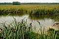
Swamp on Mitiaro.
-

Topographic map of Mitiaro.
.jpg)
.jpg)
See also
 In Spanish: Mitiaro para niños
