Mitkof Island facts for kids
Mitkof Island is a beautiful island located in southeast Alaska. It is part of a group of islands known as the Alexander Archipelago. This island sits between Kupreanof Island to its west and the main part of Alaska to its east.
Mitkof Island is about 16 kilometers (10 miles) wide and 28 kilometers (17 miles) long. Its total land area is about 539.7 square kilometers (208.4 square miles). This makes it the 30th largest island in the United States. A big part of the island is managed as part of the Tongass National Forest, which is a huge national forest.
Contents
Island Landscape and Nature
Mitkof Island is mostly flat, but it has many muskegs. Muskegs are a type of wetland with thick layers of moss and peat. The highest point on the island is Crystal Mountain, which stands at 3,317 feet (1,011 meters) tall.
Much of the island's natural beauty is protected. The Tongass National Forest helps to preserve the island's unique environment. This includes its forests, wetlands, and wildlife.
People and Towns
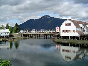
The main town on Mitkof Island is Petersburg. It is located on the northern end of the island. In the year 2000, almost everyone living on the island lived in Petersburg. The total population of the island was 3,364 people at that time.
Petersburg is known for its fishing industry and its strong Norwegian heritage. It is a lively community that plays an important role in the region.
Surrounding Waters and Passages
Mitkof Island is surrounded by several important bodies of water. To the north is Frederick Sound. To the east, you'll find Dry Strait. Sumner Strait is to the south, and Wrangell Narrows is to the west.
The Wrangell Narrows is a very special waterway. It is bordered by Mitkof Island on one side and Kupreanof and Woewodski Islands on the other. This narrow passage is the only navigable part of the 'Inside Passage' at this latitude. The Inside Passage is a famous route for ships traveling along the coast.
Because the Wrangell Narrows and Dry Strait are not very deep, the largest cruise ships cannot pass through them. Spirit Creek is the southernmost stream on the island. It flows into the Wrangell Narrows, close to where the narrows opens into Sumner Strait.
Island History
The first European person to see Mitkof Island was James Johnstone. He was an officer working with George Vancouver during his expedition between 1791 and 1795. Johnstone sighted the island in 1793.
Later, in 1844, a Russian map showed Mitkof Island as separate from Kupreanof Island. The name "Mitkof" was officially published in 1848 on a Russian chart. The island was named "Os(trov) Mitkova" in honor of Admiral Prokofy Mitkov.
See also
 In Spanish: Isla de Mitkof para niños
 | Anna J. Cooper |
 | Mary McLeod Bethune |
 | Lillie Mae Bradford |


