Moapa, Nevada facts for kids
Quick facts for kids
Moapa, Nevada
|
|
|---|---|

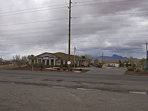
Moapa US Post Office
|
|

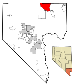
Location of Moapa in Clark County, Nevada
|
|
| Country | United States |
| State | Nevada |
| County | Clark |
| Area | |
| • Total | 17.85 sq mi (46.24 km2) |
| • Land | 17.85 sq mi (46.24 km2) |
| • Water | 0.00 sq mi (0.00 km2) |
| Elevation | 1,611 ft (491 m) |
| Population
(2020)
|
|
| • Total | 1,006 |
| • Density | 56.35/sq mi (21.76/km2) |
| Time zone | UTC−8 (PST) |
| • Summer (DST) | UTC−7 (PDT) |
| ZIP Code |
89025
|
| Area code(s) | 702 and 725 |
| FIPS code | 32-47840 |
| GNIS feature ID | 1852656 |
| Website | Advisory board homepage |
Moapa is a small community in Clark County, Nevada, United States. It is known as an unincorporated town and a census-designated place (CDP). This means it's a community that isn't officially a city or town with its own local government, but it's recognized for collecting population data.
In 2010, about 1,025 people lived in Moapa. It is the largest town in Clark County based on its land size. Moapa is also home to two of the tallest structures in Nevada: the Moapa Entravision Tower and the Moapa Kemp Tower.
Contents
Discovering Moapa's Past
The first people to settle permanently in Moapa arrived in 1865. This marked the beginning of the community.
Moapa on the Big Screen
Moapa has a small connection to early Hollywood! Two short silent movies were filmed here. Black Cyclone was filmed in 1925. Later, in 1927, Flying Elephants was filmed here. This movie starred the famous comedy duo Laurel and Hardy.
Understanding the 2010 Wildfire
On July 1, 2010, a wildfire started in Moapa. The fire spread across a large area. It damaged at least 15 buildings, especially in the Warm Springs Ranch area.
Moapa's Location and Size
Moapa is located in Clark County, Nevada. The United States Census Bureau reports that Moapa covers about 150.8 square miles (390.5 square kilometers). All of this area is land, with no water.
Who Lives in Moapa?
| Historical population | |||
|---|---|---|---|
| Census | Pop. | %± | |
| 2000 | 928 | — | |
| 2010 | 1,025 | 10.5% | |
| 2020 | 1,006 | −1.9% | |
| U.S. Decennial Census | |||
In 2000, there were 928 people living in Moapa. The population density was about 6.2 people per square mile. This means the area is not very crowded.
Most households in Moapa were families. Many of these families had children under 18 living with them. The average household had about 3.4 people.
The population of Moapa includes people of different ages. In 2000, about 38.8% of the people were under 18 years old. The median age was 29 years.
Learning in Moapa
Moapa has a public library. It is part of the Las Vegas-Clark County Library District. This library provides books and resources for everyone in the community.
Important Structures in Moapa
Moapa is home to some very tall structures. The Moapa Entravision Tower is one of the tallest structures in Nevada. It stands about 1,400 feet (427 meters) tall.
The Reid Gardner Power Plant
Moapa was also home to the Reid Gardner Generating Station. This was a large power plant that used coal to make electricity. It was owned by NV Energy and the California Department of Water Resources. Most parts of this plant closed down in 2014. The last part of the plant stopped operating in 2017.
See also
 In Spanish: Moapa Town (Nevada) para niños
 | Selma Burke |
 | Pauline Powell Burns |
 | Frederick J. Brown |
 | Robert Blackburn |


