
Monroe, Tippecanoe County, Indiana facts for kids
Quick facts for kids
Monroe
|
|
|---|---|

Tippecanoe County's location in Indiana
|
|

Monroe
Location in Tippecanoe County, Indiana
|
|
| Country | United States |
| State | Indiana |
| County | Tippecanoe |
| Township | Lauramie |
| Elevation | 787 ft (240 m) |
| Time zone | UTC-5 (Eastern (EST)) |
| • Summer (DST) | UTC-4 (EDT) |
| ZIP code |
47905
|
| Area code(s) | 765 |
| GNIS feature ID | 439339 |
Monroe is a small place in Indiana that isn't officially a town or city. It's called an unincorporated community. You can find it in Tippecanoe County, within Lauramie Township. Monroe is also part of the larger Lafayette area.
A Look Back: Monroe's History
Monroe has a short but interesting history. It first got a post office in 1836. Back then, it was called Huntersville. A few years later, in 1840, its name changed to Monroe. The post office stayed open until 1853.
When Monroe was first planned, it had a clear street layout. There were three main streets running from northwest to southeast: Darlington, Main, and Patterson. Three other streets ran from northeast to southwest: Fayette, Columbia, and Lauramie.
Where is Monroe?
Monroe is located in a mostly open farmland area. It sits where US Route 52 and County Road 900 South meet. This spot is about 10 miles southeast of the city of Lafayette. It's also less than two miles east of the town of Stockwell.
On the west side of Monroe, you'll find the Monroe Cemetery. A small stream called Lauramie Creek flows westward just south of the community.
Images for kids
-
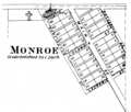
Monroe in 1878
-
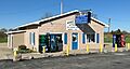
Monroe's single store
-
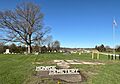
Monroe Cemetery


