Mont Sainte-Cécile facts for kids
Quick facts for kids Mont Sainte-Cécile |
|
|---|---|

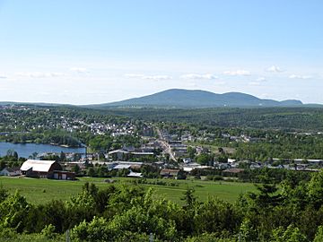
The village of Lac-Mégantic with Mont Sainte-Cécile in the background
|
|
| Highest point | |
| Elevation | 887 m (2,910 ft) |
| Isolation | 26.36 km (26,360 m) |
| Geography | |
| Parent range | Longfellow Mountains |
| Topo map | NTS 21 E/10 |
Mont Sainte-Cécile, also known as Petit-Mégantic, is a mountain in Quebec, Canada. It stands 887 meters (2,910 feet) tall.
Contents
What's in a Name?
Mont Sainte-Cécile and the village at its base are both named after Saint Cecilia. She is a famous saint.
Where is Mont Sainte-Cécile?
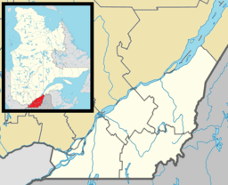
The mountain is found in the town of Sainte-Cécile-de-Whitton, Quebec. This area is part of the Le Granit region. Mont Sainte-Cécile is located within the Longfellow Mountains. These mountains are a part of the larger Appalachian Mountains range. It also sits near the Chaudière River valley.
What is the Mountain Made Of?
Mont Sainte-Cécile is mostly made of a rock called granodiorite. This type of rock formed about 370 million years ago. Today, people are taking granite from the eastern side of the mountain. Granite is a strong and beautiful rock often used in buildings.
Wildlife on the Mountain
A special type of lichen lives on Mont Sainte-Cécile. This lichen is called Pseudevernia cladonia. It is also known as "ghost antler lichen" because of its unique shape. This species is considered to be of "special concern." This means it needs protection to make sure it continues to thrive.
Can You Hike Mont Sainte-Cécile?
Currently, there are no official hiking trails or tourist areas on Mont Sainte-Cécile. There was a plan to build a hiking trail from the bottom to the top of the mountain. However, the people organizing the project could not get permission from all the landowners. Because of this, the plan for the trail has been put on hold.
 | Anna J. Cooper |
 | Mary McLeod Bethune |
 | Lillie Mae Bradford |


