
Montagne des Érables facts for kids
Quick facts for kids Montagne des Érables |
|
|---|---|

l'Acropole des Draveurs, a face of
the mountain, in the foreground |
|
| Highest point | |
| Elevation | 1,048 m (3,438 ft) |
| Prominence | 408 m (1,339 ft) |
| Isolation | 5.51 km (18,100 ft) |
| Naming | |
| English translation | Maple Mountain |
| Language of name | fr |
| Geography | |

Montagne des Érables
Location in Quebec
|
|
| Parent range | Laurentian Mountains |
| Topo map | 21 M/16 |
| Climbing | |
| Easiest route | hiking |
| Access | entrance to the Hautes-Gorges-de-la-Rivière-Malbaie National Park |
The Montagne des Érables, also called Maple Mountain, is a large mountain in Quebec, Canada. It's part of the Laurentian Mountains range. This mountain is found inside the Hautes-Gorges-de-la-Rivière-Malbaie National Park. It's famous for a challenging hiking trail called l'Acropole des Draveurs. You can reach the mountain through the park's main entrance in Saint-Aimé-des-Lacs.
Contents
What's in a Name?

The name Montagne des Érables means 'Maple Mountain' in French. It got this name because of the special maple trees that grow there. These maples are found next to areas of alpine tundra, which is unusual for this northern location.
Mountain Features

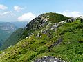
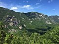
The Montagne des Érables is a large mountain area. It includes a famous rock face called l'Acropole des Draveurs, which means 'Raftsmen's Acropolis'. This part of the mountain looks over the Malbaie River valley. It stands more than 800 meters (2,625 feet) high.
Besides the Acropolis, the mountain has a big, hilly top. Here, you can find several lakes, such as Pic Chevelu, Pic Maculé, and Moucherolle lakes.
How the Mountain Was Formed
The mountain is mostly made of strong rocks called gneiss and migmatite. These rocks are very old. The western side of the mountain shows a clear view of the earth's crust's top layer. Even though the Laurentian Mountains are one of the oldest mountain ranges on Earth and have been worn down a lot by erosion, you can still see big cracks on this mountain and others nearby. These cracks are caused by pressure from a large crack in the Earth's surface called the Hautes Gorges fault.
Plants and Animals
A big part of the mountain is protected as the Grands-Ormes Ecological Reserve. This is because it has a special forest with maple trees, American elm, and black ash. This forest is rare for such a northern place.
The very top of the mountain has no trees. Instead, it's covered with alpine tundra and krummholz. Tundra is a type of land where the ground is frozen for most of the year, and only small plants grow. Krummholz refers to stunted, twisted trees that grow in harsh, windy conditions. This delicate plant life can be easily damaged by people walking on it.
From 2004 to 2012, a small group of woodland caribou lived on the mountain's summit. These caribou are a type of deer. However, since 2013, no caribou have been seen there.
Mountain History
The Montagne des Érables played a small role in the Quebec City bid for the 2002 Winter Olympics. People thought about using the Acropole des Draveurs for the downhill skiing events. This was because it has a very high prominence, meaning it stands out a lot from the land around it.
However, the mountain had no buildings or facilities for skiing. Also, it's in a very special natural area. So, this idea was not chosen. Environmental groups and local communities wanted to protect the region. Because of this, the government decided to create the Hautes-Gorges-de-la-Rivière-Malbaie National Park in 2000. This helped protect the beautiful natural landscape.
Fun Activities
Hiking the Acropole des Draveurs
The Acropole des Draveurs trail lets you hike to the top of the mountain. This trail is located near the Hautes-Gorges-de-la-Rivière-Malbaie National Park. To get to the start of the trail, hikers need to take a bus from the park's reception area.
The hike is 10 kilometers (about 6.2 miles) long, going up and back down. You gain about 800 meters (2,625 feet) in height. In the early 2000s, stone steps were added to make the trail easier to use. Even with these improvements, it is still known as one of the most challenging hikes in Quebec.
Images for kids
-
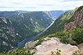
View of the Malbaie River from the top.
-
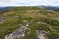
Alpine tundra covers its summit.
-
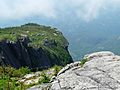
Acropolis of the Draveurs.
-
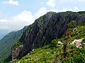
Rock wall.
-
One of the mountain peaks.
-
View from the western slopes of the Acropolis des Draveurs.


