
Montaña de Oro State Park facts for kids
Quick facts for kids Montaña de Oro State Park |
|
|---|---|
 |
|

Montaña de Oro State Park
Location in California

Montaña de Oro State Park
Location in the United States
|
|
| Location | San Luis Obispo County, California |
| Nearest city | Los Osos, Morro Bay, San Luis Obispo |
| Area | 8,000 acres (32.4 km2) |
| Governing body | California Department of Parks and Recreation |
Montaña de Oro is a beautiful state park in California, United States. Its name means "Mountain of Gold" in Spanish. This name comes from the many golden wildflowers that bloom here. The park is located about six miles southwest of Morro Bay and two miles south of Los Osos.
Montaña de Oro State Park covers 8,000 acres (32 km²). It has tall cliffs, seven miles of shoreline, and sandy beaches. You can also find coastal plains, streams, canyons, and hills here. One of the highest points is Valencia Peak, which is 1,347 feet (411 m) tall. The park is a great place for outdoor activities. It has many trails for hiking, mountain biking, and horse riding. There are also special camps for horses. A simple campground is located across from Spooner's Cove, a popular beach. The Bluff Trail is an easy and scenic path along the coast. Other trails lead to the tops of Valencia Peak, Oats Peak, and Hazard Peak.
Contents
Native American History at Montaña de Oro
Who lived here before Europeans arrived?
About 500 years ago, before Europeans came to California's central coast, the land was home to the Chumash and Salinan people. It is thought that 20,000 to 30,000 of them lived in small villages. Their territory stretched from Morro Bay south to Malibu.
How did the Chumash people live?
The Chumash people relied a lot on the ocean for food. However, they also used many other sources for food, clothing, and shelter. They were part of a large trading network with other groups. When Spanish explorers visited the Montaña de Oro area in 1542, they wrote that the local people were friendly. They even paddled out in canoes to greet the explorers.
What happened when the Spanish arrived?
In 1769, Don Gaspar de Portola led his troops north from San Diego. He wanted to claim new land for the king of Spain. This started the Mission period in California. During this time, many Native Americans became sick from European diseases. They had no natural protection against these illnesses.
The Park's Journey to Becoming a State Park
Early Land Ownership and Ranching
After California became part of the United States, the land that is now Montaña de Oro State Park changed owners many times. Part of the park was once a large ranch called Rancho Cañada de los Osos. This ranch was given to Victor Linares in 1842 by Governor Juan B. Alvarado. It was located west of San Luis Obispo.
Victor Linares later sold his ranch to James Scott and John Wilson. They also bought a nearby ranch called Rancho Pecho y Islay. In 1845, they combined these lands into an even larger ranch of 32,431 acres.
Life on the Ranch: Spooner and Hazard
For many years, the land was mostly used for raising sheep. In 1892, Alden B. Spooner, Jr., leased some land around Islay Creek. He later bought it. Spooner brought in dairy cattle, hogs, and other farm animals. His two sons started the Pecho Ranch & Stock Co. They built a ranch house, barns, a creamery, and stables. They even used a waterwheel to create power.
On the south bluff of Spooner's Cove, they had a warehouse. A long chute led from the warehouse down to a wharf. A loading boom helped them load goods onto coastal ships. Just north of Spooner's land, Alexander S. Hazard owned property. He also farmed and had a dairy. Hazard hoped to make money from California's need for wood. He planted hundreds of eucalyptus trees, hoping to create a lumber farm in Hazard Canyon. However, eucalyptus wood was not good for commercial use.
Changes and Challenges for the Land
In the early 1940s, a flood swept through Hazard Canyon. In 1947, a grass fire burned up the coast from Diablo Canyon. This fire destroyed many of Hazard's dairy buildings. But Hazard's eucalyptus trees still stand today.
Rancher Oliver C. Field bought the land in the early 1940s. About ten years later, he sold it to Irene McAllister. In 1965, the State of California bought the property to create a state park. They decided to keep the name McAllister had given it: "Montaña de Oro."
Becoming a California State Park
On April 24, 1965, Rancho Montaña de Oro officially became a California State Park. The state bought the land through a special program. This program was launched by Governor Edmund G. "Pat" Brown to acquire parkland.
The property was owned by Rancho Montaña de Oro, Inc., which belonged to Irene M. Starkey. Charles De Turk, the California Beaches and Parks Director, worked with Morris J. Lavine, a lawyer involved in the sale. They made sure the property was held until the Parks Department could buy it. For a long time, Montaña de Oro had the longest untouched coastal area of any public land in California.
Protecting Ocean Life: Marine Protected Areas
Off the coast of Montaña de Oro, there are special areas called marine protected areas. These include the Morro Bay State Marine Recreational Management Area and Morro Bay State Marine Reserve and the Point Buchon State Marine Reserve and Marine Conservation Area. These areas are like underwater parks. They help protect ocean wildlife and the natural ocean environments. This ensures that marine animals and plants can thrive.
Images for kids
-
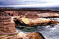
Submarine Rock, Montaña de Oro coast
-
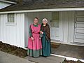
Spooner Ranch House living history program, 2005
-
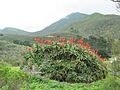
Flower
-
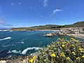
Northward view of Spooner's Cove via Bluff Trail, with Morro Bay in the distance. June 12, 2021


