
Montjay, Hautes-Alpes facts for kids
Quick facts for kids
Montjay
|
||
|---|---|---|
 |
||
|
||

Montjay
Location in France

Montjay
Location in Provence-Alpes-Côte d'Azur
|
||
| Country | France | |
| Region | Provence-Alpes-Côte d'Azur | |
| Department | Hautes-Alpes | |
| Arrondissement | Gap | |
| Canton | Serres | |
| Area
1
|
27 km2 (10 sq mi) | |
| Population
(Jan. 2019)
|
104 | |
| • Density | 3.85/km2 (9.98/sq mi) | |
| Time zone | UTC+01:00 (CET) | |
| • Summer (DST) | UTC+02:00 (CEST) | |
| INSEE/Postal code |
05086 /05150
|
|
| Elevation | 764–1,298 m (2,507–4,259 ft) (avg. 814 m or 2,671 ft) |
|
| 1 French Land Register data, which excludes lakes, ponds, glaciers > 1 km2 (0.386 sq mi or 247 acres) and river estuaries. | ||

Montjay is a small and charming commune in the Hautes-Alpes department of southeastern France. A commune is like a small town or village with its own local government. Montjay is known for its quiet, natural surroundings.
Contents
Where is Montjay?
Montjay is located in the Hautes-Alpes department, which is part of the Provence-Alpes-Côte d'Azur region in France. This area is famous for its beautiful mountains and sunny weather. The commune shares a border with the Drôme department, another part of France known for its lavender fields and olive groves.
How Many People Live There?
Montjay is a very small commune. Its population has changed a bit over the years. For example, in 1962, about 75 people lived there. By 1968, the number grew to 102. In recent years, the population has stayed around 100 people, making it a peaceful place to live.
Getting Around Montjay
Even though Montjay is small, it has roads that help people get around. The D226 and D949 roads pass through the commune. These roads connect Montjay to nearby villages and towns, making it easier for residents and visitors to travel.
Images for kids
-
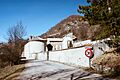
A view of Montjay, showing its peaceful surroundings.
See also
 In Spanish: Montjay (Altos Alpes) para niños
