
Montmorenci, Indiana facts for kids
Quick facts for kids
Montmorenci, Indiana
|
|
|---|---|

Montmorenci's grain elevators silhouetted at dusk
|
|

Location of Montmorenci in Tippecanoe County, Indiana.
|
|
| Country | United States |
| State | Indiana |
| County | Tippecanoe |
| Township | Shelby |
| Area | |
| • Total | 1.59 sq mi (4.13 km2) |
| • Land | 1.59 sq mi (4.12 km2) |
| • Water | 0.00 sq mi (0.01 km2) |
| Elevation
<
|
692 ft (211 m) |
| Population
(2020)
|
|
| • Total | 173 |
| • Density | 108.74/sq mi (41.99/km2) |
| Time zone | UTC-5 (Eastern (EST)) |
| • Summer (DST) | UTC-4 (EDT) |
| ZIP code |
47906
|
| Area code(s) | 765 |
| GNIS feature ID | 2583460 |
Montmorenci is a small community located in Shelby Township, Tippecanoe County, Indiana. It is an "unincorporated" area, meaning it doesn't have its own city government. However, it is a "census-designated place," which means the government counts its population for official records. Sometimes, older maps might spell its name as Montmorency or Montmorencie. Montmorenci is part of the larger Lafayette Metropolitan Statistical Area.
Contents
History of Montmorenci
Early Names and Post Office History
Montmorenci was once known by a different name: Bringham's Grove. A post office was first set up here in 1846 under that name. Later, in 1853, the post office's name was changed to Montmorenci. Today, this post office is no longer open.
Geography of Montmorenci
Where is Montmorenci Located?
Montmorenci is found in Shelby Township. It is located at about 40°28'28" North latitude and 87°01'46" West longitude. The community sits where two important roads meet: U.S. Route 52 and U.S. Route 231. The land here is about 699 feet (213 meters) above sea level.
Population of Montmorenci
How Many People Live Here?
| Historical population | |||
|---|---|---|---|
| Census | Pop. | %± | |
| 2020 | 173 | — | |
| U.S. Decennial Census | |||
According to the 2020 United States Census, Montmorenci had a population of 173 people. A "census-designated place" is a special area that the government counts for population data.
Education in Montmorenci
Past and Present Schools
In 1913, a new brick school building was constructed in Montmorenci. It cost $40,000 to build. By 1923, this school taught students from first grade all the way through twelfth grade. Because of this new school, all other smaller schools in the local area closed down.
However, the Montmorenci School itself closed in 1966. This happened as part of a plan to combine schools. Older students then began attending the new Benton Central Jr./Sr. High School.
Even though Montmorenci is in Tippecanoe County, its public schools are managed by the Benton Community School Corporation. This school district is from the neighboring Benton County. Younger students, from kindergarten to sixth grade, go to Otterbein Elementary. After that, they move on to Benton Central Junior-Senior High School for grades seven through twelve.
Images for kids
-
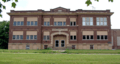
The old Montmorenci School building.
-
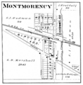
Montmorenci in 1878.
-
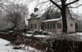
A home along Walnut Street.


See also
 In Spanish: Montmorenci (Indiana) para niños
