Montrose, Virginia facts for kids
Quick facts for kids
Montrose, Virginia
|
|
|---|---|
 |
|

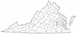
Location of Montrose, Virginia
|
|
| Country | |
| State | |
| County | |
| Area | |
| • Total | 3.3 sq mi (8.5 km2) |
| • Land | 3.2 sq mi (8.3 km2) |
| • Water | 0.08 sq mi (0.2 km2) |
| Elevation | 161 ft (49 m) |
| Population
(2020)
|
|
| • Total | 7,909 |
| • Density | 2,410/sq mi (930/km2) |
| Time zone | UTC−5 (Eastern (EST)) |
| • Summer (DST) | UTC−4 (EDT) |
| ZIP code |
23231
|
| Area code(s) | 804 |
| FIPS code | 51-52904 |
| GNIS feature ID | 1867596 |
Montrose is a community in Henrico County, Virginia, United States. It is called a "census-designated place" (CDP). This means it's an area that the government counts for the census, but it's not officially a city or town with its own local government. In 2020, about 7,909 people lived in Montrose.
Contents
Where is Montrose Located?
Montrose is found in the state of Virginia. It is part of Henrico County. You can find it on a map at these coordinates: 37 degrees 31 minutes 14 seconds North, and 77 degrees 22 minutes 42 seconds West.
Montrose's Size and Land
The total area of Montrose is about 8.5 square kilometers (which is about 3.3 square miles). Most of this area is land, around 8.3 square kilometers (3.2 square miles). A small part, about 0.2 square kilometers (0.08 square miles), is water.
How Many People Live in Montrose?
The number of people living in Montrose has changed over the years. The government counts everyone every ten years in something called a census.
| Historical population | |||
|---|---|---|---|
| Census | Pop. | %± | |
| 1980 | 5,349 | — | |
| 1990 | 6,405 | 19.7% | |
| 2000 | 7,018 | 9.6% | |
| 2010 | 7,993 | 13.9% | |
| 2020 | 7,909 | −1.1% | |
| U.S. Decennial Census 2010 2020 |
|||
In 1980, there were about 5,349 people. By 2010, the population grew to 7,993. In the most recent count in 2020, the population was 7,909. This shows that Montrose has grown quite a bit over the past few decades.
See also
 In Spanish: Montrose (Virginia) para niños
 | Frances Mary Albrier |
 | Whitney Young |
 | Muhammad Ali |

