Morley, Michigan facts for kids
Quick facts for kids
Morley, Michigan
|
|
|---|---|
|
Village
|
|

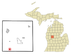
Location of Morley, Michigan
|
|
| Country | United States |
| State | Michigan |
| County | Mecosta |
| Townships | Aetna, Deerfield |
| Area | |
| • Total | 0.99 sq mi (2.56 km2) |
| • Land | 0.90 sq mi (2.32 km2) |
| • Water | 0.10 sq mi (0.25 km2) |
| Elevation | 915 ft (279 m) |
| Population
(2020)
|
|
| • Total | 517 |
| • Density | 577.65/sq mi (223.04/km2) |
| Time zone | UTC-5 (Eastern (EST)) |
| • Summer (DST) | UTC-4 (EDT) |
| ZIP code |
49336
|
| Area code(s) | 231 |
| FIPS code | 26-55540 |
| GNIS feature ID | 1620897 |
Morley is a small village located in Mecosta County, in the U.S. state of Michigan. In 2020, about 517 people called Morley home. It's a quiet place in the southwestern part of Mecosta County.
Contents
Where is Morley?
Morley is found in the southwest part of Mecosta County, Michigan. It sits right on the edge between two areas called Aetna Township and Deerfield Township.
It is about 18 miles (29 km) south of Big Rapids, which is the main town of the county. Morley is also about 7 miles (11 km) north of Howard City.
Land and Water
The village of Morley covers a total area of about 0.99 square miles (2.56 square kilometers). Most of this area, about 0.90 square miles (2.32 square kilometers), is land. The rest, about 0.10 square miles (0.25 square kilometers), is water.
The Little Muskegon River flows through the southeast part of the village. Here, the river is held back to form a small lake called Morley Pond.
Who Lives in Morley?
| Historical population | |||
|---|---|---|---|
| Census | Pop. | %± | |
| 1880 | 299 | — | |
| 1890 | 485 | 62.2% | |
| 1900 | 334 | −31.1% | |
| 1910 | 337 | 0.9% | |
| 1920 | 336 | −0.3% | |
| 1930 | 322 | −4.2% | |
| 1940 | 366 | 13.7% | |
| 1950 | 413 | 12.8% | |
| 1960 | 445 | 7.7% | |
| 1970 | 481 | 8.1% | |
| 1980 | 507 | 5.4% | |
| 1990 | 528 | 4.1% | |
| 2000 | 495 | −6.2% | |
| 2010 | 493 | −0.4% | |
| 2020 | 517 | 4.9% | |
| U.S. Decennial Census | |||
Population in 2010
According to the census from 2010, there were 493 people living in Morley. These people lived in 182 households, and 115 of these were families.
The average number of people living in one household was about 2.71. For families, the average size was about 3.28 people.
Age Groups
The average age of people in Morley in 2010 was 33.6 years old.
- About 30% of the residents were under 18 years old.
- About 7.7% were between 18 and 24 years old.
- About 24% were between 25 and 44 years old.
- Another 24% were between 45 and 64 years old.
- About 14.4% of the people were 65 years old or older.
There were slightly more females (53.3%) than males (46.7%) living in the village.
Getting Around Morley
- Bus Service: You can catch a bus from Morley to other cities like Grand Rapids and Petoskey, Michigan using a service called Indian Trails.
- Local Bus: The Mecosta Osceola Transit Authority (MOTA) also offers bus service between Morley and nearby towns.
- White Pine Trail: A part of the Fred Meijer White Pine Trail State Park goes right through Morley. This is a special path built on an old railroad track. It's 92 miles (148 km) long and is great for biking in the summer and snowmobiling in the winter!
Famous People from Morley
- Maude Farris-Luse: She was a supercentenarian, which means she lived to be a very, very old age!
See also
 In Spanish: Morley (Míchigan) para niños
 | Stephanie Wilson |
 | Charles Bolden |
 | Ronald McNair |
 | Frederick D. Gregory |

