
Mosey Run (Oil Creek tributary) facts for kids
Quick facts for kids Mosey Run |
|
|---|---|


|
|
| Other name(s) | Tributary to Oil Creek |
| Country | United States |
| State | Pennsylvania |
| County | Crawford Erie |
| Township | Bloomfield |
| Physical characteristics | |
| Main source | divide between Mosey Run and South Branch French Creek Union Township, Erie County 1,665 ft (507 m) 41°51′04″N 079°54′49″W / 41.85111°N 79.91361°W |
| River mouth | Oil Creek at Lincolnville, Pennsylvania Lincolnville, Pennsylvania 1,370 ft (420 m) 41°47′43″N 079°50′26″W / 41.79528°N 79.84056°W |
| Length | 7.5 mi (12.1 km) |
| Basin features | |
| Progression | south-southeast |
| River system | Allegheny River |
| Basin size | 180.95 square miles (468.7 km2) |
| Tributaries |
|
| Bridges | Rockdale Road, Wilkins Road, King Road, Brown Hill Road, Shreve Ridge Road |
Mosey Run is a small stream, about 7.5 miles (12.1 km) long, located in Crawford County, Pennsylvania. It's like a smaller helper stream, also known as a tributary, that flows into a bigger one called Oil Creek. Oil Creek then flows into the Allegheny River, which is part of a much larger river system.
Where Does Mosey Run Flow?
Mosey Run begins in Union Township, Erie County, Pennsylvania, high up on a land ridge. This ridge separates its waters from another stream called the South Branch French Creek.
From its start, Mosey Run flows generally towards the south-southeast. It travels through an area known as the Erie Drift Plain. Finally, it reaches its end, or mouth, when it joins Oil Creek near a place called Lincolnville, Pennsylvania.
What is Mosey Run's Watershed?
A watershed is like a big bowl or area of land where all the rain and snowmelt drain into a particular river or stream. Mosey Run's watershed covers about 180.95 square miles (468.7 km²).
This area gets a good amount of rain each year, about 46.2 inches (117 cm). A large part of the watershed, about 54%, is covered by forests. This means there are many trees that help keep the water clean and the land healthy.
Images for kids
-
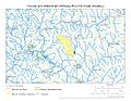
This map shows the path of Mosey Run and the area of land that drains into it.
.jpg)
