Mount Baker Tunnel facts for kids
Quick facts for kids |
|
|
Mount Baker Ridge Tunnel
|
|
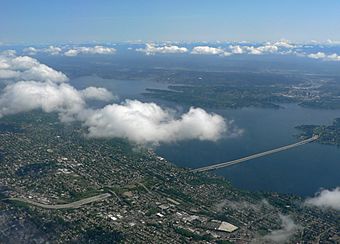
View of the Mount Baker Tunnel and the Lacey V. Murrow and Homer M. Hadley Memorial Bridges from the southwest
|
|
| Location | |
|---|---|
| Built | 1940 (original; parallel tunnel built 1989) |
| Architect | Bates & Rogers Construction Corp. |
| Architectural style | Art Deco |
| MPS | Historic Bridges/Tunnels in Washington State TR |
| NRHP reference No. | 82004243 |
| Added to NRHP | July 16, 1982 |
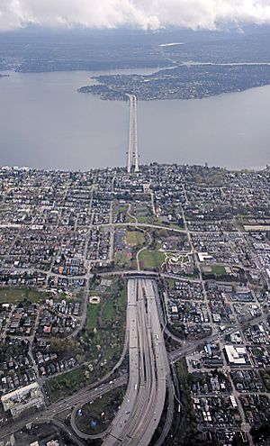
The Mount Baker Tunnel is a super important tunnel in Seattle, Washington. It helps Interstate 90 (a big highway) go right under the Mount Baker neighborhood. Imagine a giant underground pathway!
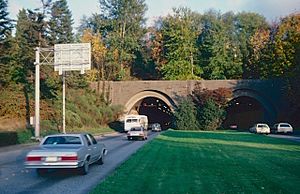
This isn't just one tunnel, but actually three tunnels working together. They carry eight lanes of highway traffic. Plus, there's a special path just for bikes and people walking. The first two tunnels were built in 1940. A newer, bigger tunnel was added in 1989. The newest tunnel is like a two-story road, with the bike and walking path on top.
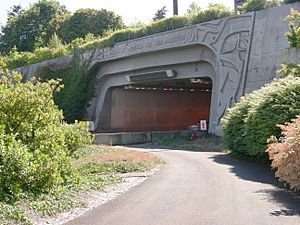
The tunnel is so important that it was added to the National Register of Historic Places in 1982. This means it's a special historical landmark. The eastern entrances of the tunnel have cool murals called Portal of the North Pacific. These were designed by an artist named James FitzGerald. These entrances, along with the nearby Lacey V. Murrow Memorial Bridge, are also official City of Seattle landmarks.
The tunnel is about 1,440 feet (440 m) long. That's almost half a kilometer! It's famous for being the world's largest tunnel dug through soft ground like clay. It's 63 feet (19 m) wide, which is super impressive!
Contents
Tunnel History and Changes
Original Tunnels (1940)
The first two tunnels were finished in 1940. They connected the Lacey V. Murrow Memorial Bridge (a floating bridge on Lake Washington) to Rainier Avenue South in Seattle. These tunnels were part of U.S. Route 10, an older highway.
Each of the two original tunnels had two lanes for cars. The north tunnel usually carried cars going west. The south tunnel usually carried cars going east. Later, in the 1960s, a special signal system was added. This system helped manage traffic during busy times. It could change the direction of the middle two lanes. For example, in the mornings, three lanes might go west and only one lane east. This helped people get to work.
Eventually, this highway became part of Interstate 90. It was then made bigger and better, becoming a modern freeway. This big upgrade finished in 1993.
Big Expansion (1983–1993)
A huge project started in 1983 to make the tunnel even bigger. Workers built a brand new, much wider tunnel. This new tunnel is located north of the original two. When the whole I-90 project was done in 1993, the original 1940 tunnels were connected to the southern floating bridge (the Lacey V. Murrow Memorial Bridge). They now carry only eastbound traffic.
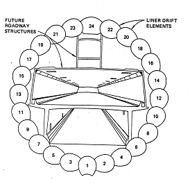
The new 1989 tunnel was connected to the northern floating bridge (the Homer M. Hadley Memorial Bridge). This new tunnel carries only westbound traffic. The original tunnels were about 29 feet (8.8 m) wide. The new tunnel is much wider, at 63 feet (19 m) across!
The new tunnel was designed to have three levels inside. The bottom level was for buses and carpools. The middle level was for regular car traffic. And the top level was for bikes and pedestrians. Digging for the new tunnel finished in 1986. The new tunnel opened to traffic in June 1989.
For a short time, the new tunnel and the Homer Hadley Memorial Bridge carried traffic in both directions. This happened while the older bridges and tunnels were being fixed up. The new tunnel opened for westbound traffic on June 4, 1989. It opened for eastbound traffic on June 23. After that, the old tunnel and floating bridge closed for renovations.
The old tunnel and bridge were supposed to reopen in three years. But a part of the Murrow Bridge sank during a storm in 1990. This caused a delay of about one year. Everything finally reopened in 1993.
When the Murrow Bridge reopened in 1993, the older Mount Baker Ridge tunnels also reopened. All their lanes now carried only eastbound traffic. Before, pedestrians could walk in the old tunnels. But after the new tunnel opened, they had a special path there. So, pedestrians were no longer allowed in the old tunnels.
The I-90 expansion project also made the Mount Baker Tunnel seem much longer. A long concrete "lid" was built over the freeway. This covered a section of the road. Inside the older tunnels, the arch-shaped ceilings were made square. This matched the new "lidded" section. New equipment was also added to help boost radio signals inside the tunnels.
How the Tunnels Work Today
After the big I-90 expansion in the 1990s, the freeway could handle much more traffic. There are now three regular lanes in each direction. There are also two special lanes for carpools (called HOV lanes) that can change direction.
Eastbound traffic uses the original tunnels. Westbound traffic uses the upper deck of the newer, northern tunnel. A two-lane road on the lower deck of the new tunnel can change direction. This road used to be for express buses and carpools during busy times. It would go westbound in the mornings and eastbound in the afternoons. On weekends, the direction could change depending on traffic.
Above the westbound traffic in the new tunnel is the I-90 Trail tunnel. This is a long path for bikes and walkers. It's about 1,330 feet (410 m) long! On the western side, the trail comes out onto a park area called Lid Park.
In 2017, the Washington State Department of Transportation changed the reversible express lanes on I-90. These lanes are now being used for the East Link light rail project. This project will bring Link light rail train service from Seattle to Bellevue and Redmond in 2023.
|


