Mercer Island, Washington facts for kids
Quick facts for kids
Mercer Island, Washington
|
||
|---|---|---|
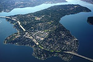
Aerial view of Mercer Island from the north
|
||
|
||
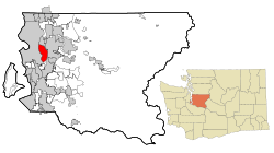
Location of Mercer Island in King County, Washington
|
||
| Country | United States | |
| State | Washington | |
| County | King | |
| Incorporated | July 5, 1960 | |
| Government | ||
| • Type | Council–manager | |
| Area | ||
| • Total | 12.90 sq mi (33.41 km2) | |
| • Land | 6.38 sq mi (16.53 km2) | |
| • Water | 6.52 sq mi (16.88 km2) | |
| Elevation | 75 ft (23 m) | |
| Population
(2020)
|
||
| • Total | 25,748 | |
| • Estimate
(2024)
|
25,302 | |
| • Density | 3,880/sq mi (1,497/km2) | |
| Time zone | UTC−8 (Pacific (PST)) | |
| • Summer (DST) | UTC−7 (PDT) | |
| ZIP Code |
98040
|
|
| Area code(s) | 206 | |
| FIPS code | 53-45005 | |
| GNIS feature ID | 2411082 | |
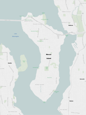
Mercer Island is a city in King County, Washington, United States. It is located on an island of the same name in the southern part of Lake Washington. Mercer Island is part of the Seattle metropolitan area. The city of Seattle is to its west, and Bellevue is to its east.
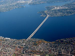
The island connects to the mainland on both sides by bridges. These bridges carry Interstate 90. The Lacey V. Murrow Memorial Bridge and the Homer M. Hadley Memorial Bridge are floating bridges. They cross Lake Washington, connecting Mercer Island to Seattle. Interstate 90 then crosses the East Channel of Lake Washington to Bellevue using the East Channel Bridge. Mercer Island is closer to Bellevue than Seattle. Because of this, it is often considered part of King County's Eastside.
In 2020, the population of Mercer Island was 25,748 people. Mercer Island is known as one of the richest ZIP codes in the U.S.
Contents
History of Mercer Island
The western side of Mercer Island was once home to two Snoqualmie villages. This was before white settlers arrived in the Puget Sound area. The island got its name from the Mercer family of Seattle. Non-Native people first settled here between 1870 and 1880. The Mercer brothers, Thomas Mercer and Asa Mercer, would often row from Seattle to the island. They came to pick berries, hunt, and fish.
The first large settlement was called East Seattle. It was located on the northwest side of the island. In 1889, a man named C.C. Calkins built a fancy resort called the Calkins Hotel. Guests could reach the hotel by steamboat. The steamboats traveled between Madison Park, Leschi Park, and the Eastside. Famous guests included President Benjamin Harrison. The hotel burned down in a mysterious fire in 1908.
The Calkins Landing continued to operate. This helped more people settle on the island permanently. A busier town with a business area grew in the central northern part of the island. This area now makes up most of the island's main ridge.
Building Bridges to Connect the Island
In 1923, the East Channel Bridge was built. This bridge connected the island with Bellevue. In 1930, George W. Lightfoot asked for a bridge between Mercer Island and Seattle. The Lacey V. Murrow Memorial Bridge opened in 1940. It is currently the second-longest floating bridge in the world.
In 1989, a second bridge, the Homer M. Hadley Memorial Bridge, was built next to the Lacey V. Murrow Memorial Bridge. These three bridges carry Interstate 90. They connect Seattle, cross Mercer Island, and continue into Bellevue.
Becoming a City
The City of Mercer Island was officially formed on July 5, 1960. It included all of the island except for a 70-acre business district. Just over a month later, on August 9, that business district also became its own town, called the Town of Mercer Island. The two towns then joined together to form the City of Mercer Island on May 19, 1970.
Geography and Climate
Mercer Island City Hall was located at 47°34′14″N 122°13′19″W / 47.57056°N 122.22194°W. It closed in April 2023 because asbestos was found in the air system. As of July 2025, the city is still planning for a new building.
The highest point on the island is about 335 feet (102 meters) high. This peak is near the center of the island.
Mercer Island covers a total area of 12.90 square miles (33.41 square kilometers). About 6.38 square miles (16.53 square kilometers) is land, and 6.52 square miles (16.88 square kilometers) is water. The ZIP Code for Mercer Island is 98040.
Mercer Island is the most populated island located in a lake in the United States.
Mercer Island's Climate
Mercer Island has warm, dry summers. The average monthly temperatures do not go above 71.6°F (22°C). This type of weather is called a warm-summer Mediterranean climate.
Education in Mercer Island
The Mercer Island School District runs seven schools on the island:
- Four elementary schools: Lakeridge, Island Park, West Mercer, and Northwood.
- One middle school: Islander Middle School.
- One high school: Mercer Island High School.
- One alternative secondary school: Crest Learning Center.
Mercer Island also has some private schools. These include St. Monica Catholic School, the French American School of Puget Sound, and the Northwest Yeshiva High School.
Population and People
| Historical population | |||
|---|---|---|---|
| Census | Pop. | %± | |
| 1970 | 19,047 | — | |
| 1980 | 21,522 | 13.0% | |
| 1990 | 20,816 | −3.3% | |
| 2000 | 22,036 | 5.9% | |
| 2010 | 22,699 | 3.0% | |
| 2020 | 25,748 | 13.4% | |
| 2024 (est.) | 25,302 | 11.5% | |
| United States Census Bureau 2020 Census |
|||
About 25% of the homes in Mercer Island are Jewish. The island has two synagogues and a Jewish Community Center.
2020 Census Information
In 2020, Mercer Island had 25,748 people living there. There were 9,927 households and 7,105 families. The population density was about 4033.8 people per square mile (1557.5 per square kilometer).
The racial makeup of the city was:
- 63.6% White
- 1.1% Black or African American
- 0.1% Native American
- 22.9% Asian
- 0.1% Pacific Islander
- 0.7% from some other races
- 6.9% from two or more races
About 4.6% of the population was Hispanic or Latino (of any race).
About 23.1% of residents were under 18 years old. About 4.0% were under 5 years old. And 20.4% were 65 years or older. The average household had 2.54 people. The average family had 3.03 people.
The median income for a household was $150,506.
Government and Services
Mercer Island uses a Council–manager government. This means the city council chooses the mayor. The City Hall building has offices for the City Manager, other city workers, the court, and the police department.
Mercer Island is part of Washington's 9th congressional district for national government. This district is currently represented by Democrat Adam Smith. For state government, Mercer Island is in the 41st Legislative District.
The Mercer Island Fire Department has two stations. The Mercer Island Police Department has one station. The city does not treat its own drinking water or wastewater. King County handles wastewater treatment for the island. The Public Works Department manages city streets and other services.
In February 2021, the city council passed a rule. It stopped outdoor camping on public property. This rule mainly aimed to limit homeless people from staying overnight. Some groups, like the American Civil Liberties Union, did not agree with this rule.
Parks and Recreation
Mercer Island has many parks for people to enjoy.
- Luther Burbank Park is 77 acres (31 hectares) and has 0.75 miles (1.2 kilometers) of waterfront. It has a public boat dock, fishing pier, swimming beach, and tennis courts. There are also picnic areas and a special off-leash area for dogs.
- The Aubrey Davis Park is located on top of the Interstate 90 tunnel entrances. This park has softball fields, tennis courts, basketball courts, and picnic shelters. It is also home to the Freeway Sculpture Park. People sometimes call it "The Lid" because it covers the freeway.
- Pioneer Park is 113 acres (46 hectares). It has trails for horses, bikes, and hiking.
- Deane's Children's Park, also known as "Dragon Park," is a small park. It has playground equipment, including a large concrete dragon.
- Clarke Beach is at the south end of Mercer Island. It is famous for the annual polar bear swim on New Year's Day.
The city also takes care of many smaller parks. Some of these parks have access to the waterfront. In 2010, the city built a well in Rotary Park. This well helps supply water in case of a major disaster, like an earthquake.
Culture and Events
Sister City
Mercer Island has a sister city. This is a special friendship with another city in a different country. Mercer Island's sister city is Thonon-les-Bains, France.
Annual Events
- Summer Celebration is a yearly event that happens the weekend after the 4th of July. It was canceled in 2019 due to budget cuts but was brought back in 2022.
- The Mercer Island Farmers Market is open most Sundays from June to October. It sells local fruits, vegetables, and some crafts. There is also a special Harvest Market in November.
Notable People from Mercer Island
Many well-known people have lived in Mercer Island, including:
- Paul Allen, who helped start Microsoft
- Matthew Boyd, a baseball pitcher
- Ann Dunham, the mother of former President Barack Obama
- Aaron Levie, CEO of Box, Inc.
- Rashard Lewis, a former NBA basketball player
- Howard Lincoln, former chairman of Nintendo of America
- Joel McHale, an actor and comedian
- Michael Medved, a radio host and writer
- Steve Miller from the Steve Miller Band
- Jordan Morris, a soccer player for the Seattle Sounders FC
- Alan Mulally, former CEO of Ford
- Ted Rand, an illustrator
- Bill Russell, a famous NBA basketball player and coach
- Kyle Seager, a former baseball player
- Frank Shrontz, former CEO of Boeing
- Quin Snyder, a basketball coach
- Mary Wayte, an Olympic gold medal swimmer
Transportation Around Mercer Island
Interstate 90 cuts through Mercer Island. It connects the city to Seattle in the west and Bellevue in the east. The freeway crosses Lake Washington on the Lacey V. Murrow and Homer M. Hadley floating bridges to Seattle. It then crosses the East Channel Bridge towards Bellevue. These bridges also have paths for walking and biking. A large part of the freeway on the island is underground. This area is covered by the Mercer Island Lid, which includes several parks.
Public transportation is provided by King County Metro and Sound Transit. They offer express bus routes to Seattle and the Eastside. Many routes connect to a park and ride facility on the north side of the island. This facility has 447 parking spots. It was expanded in 2008 to a two-story parking garage. Metro Route 204 provides all-day bus service for most of the island.
A light rail station at the park and ride facility opened in early 2026. This station is part of the 2 Line and connects Mercer Island to Seattle and the Eastside. The light rail line replaced several express bus routes on Interstate 90. Mercer Island is now a major place where people switch between buses and the light rail.
See also
 In Spanish: Mercer Island (Washington) para niños
 | DeHart Hubbard |
 | Wilma Rudolph |
 | Jesse Owens |
 | Jackie Joyner-Kersee |
 | Major Taylor |


