Mount Blue (Maine) facts for kids
Quick facts for kids Mount Blue |
|
|---|---|

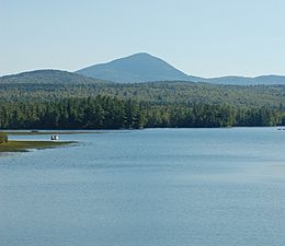
Mt. Blue, seen from the north side of Webb Lake
|
|
| Highest point | |
| Elevation | 3202 NAVD 88 |
| Prominence | 1,840 ft (560 m) |
| Listing | 49 New England Fifty Finest |
| Geography | |
| Topo map | USGS Mount Blue |
| Climbing | |
| Easiest route | Hiking, class 1 |
Mount Blue is a cool mountain located in Maine, USA. It's so important that a state park and even a high school are named after it! You can find Mount Blue State Park in Weld and Mount Blue High School in Farmington.
Mount Blue: A Fun Mountain to Explore
Reaching the Top
If you want to hike to the top of Mount Blue, you can start on Mt Blue Road in Weld. This road is mostly dirt and about 4.1 kilometers (2.5 miles) long. You can park your car at the end of the road.
From the parking area, the hike to the top is about 1.6 kilometers (1 mile). The trail is very steep and rocky, so it's a challenging climb! It's important to be careful because the path can be tricky.
Experienced hikers might reach the top in about 1.5 to 2 hours. If you're hiking for fun, it might take you 2 to 3 hours. Once you get to the summit, you'll see amazing views in many directions! There's also a special platform on a cell phone tower where you can enjoy the scenery even more.
Lakes Nearby
Just west of Mount Blue is Webb Lake. This lake is quite shallow but very large, covering about 2,124 acres (8.6 square kilometers). People can visit Webb Lake and try to catch different kinds of fish, like brook trout.
About 3 kilometers (1.9 miles) north of Mount Blue, you'll find Mount Blue Pond. This pond is smaller, about 134 acres (0.54 square kilometers). It's also open to the public and is known for being a good spot for fishing.
 | Lonnie Johnson |
 | Granville Woods |
 | Lewis Howard Latimer |
 | James West |


