Mount Burrell facts for kids
Quick facts for kids Mount BurrellNew South Wales |
|
|---|---|

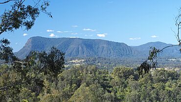
Distant view of Mount Burrell, from the west
|
|
| Population | 484 (2011 census) |
| Postcode(s) | 2484 |
| Time zone | AEST (UTC+10) |
| • Summer (DST) | AEDT (UTC+11) |
| LGA(s) | Tweed Shire |
| Region | Northern Rivers |
| State electorate(s) | Tweed |
| Federal Division(s) | Richmond |
| Burrell | |
|---|---|
| Blue Knob | |
| Highest point | |
| Elevation | 933 m (3,061 ft) |
| Geography | |
| Location | Northern Rivers region of New South Wales, Australia |
| Parent range | Nightcap Range |
Mount Burrell is a small town and a mountain located in the Nightcap Range. It is found in the Tweed Shire area of the Northern Rivers region in New South Wales, Australia.
The top of Mount Burrell is 933 metres (3,061 ft) (about 3,061 feet) above sea level. This mountain is located about 8 kilometres (5.0 mi) (5 miles) north of the town of Nimbin.
Who Lives in Mount Burrell?
In 2011, about 484 people lived in Mount Burrell. Slightly more than half of the residents were male (50.2%), and just under half were female (49.8%).
The average age of people in Mount Burrell was 47 years old. This is 10 years older than the average age for all of Australia.
Where People Are From
Most people living in Mount Burrell were born in Australia (77.9%). Other countries where residents were born include:
- England (5%)
- New Zealand (2.9%)
- Germany (1.2%)
- Switzerland (1%)
- Fiji (0.8%)
People from many other countries also make up the remaining 10.9% of the population.
Languages Spoken
Most people in Mount Burrell speak only English at home (91.9%). Other languages spoken include:
- German (1.7%)
- Dutch (1%)
- African Languages (1%)
About 3.7% of people speak other languages at home.
 | William Lucy |
 | Charles Hayes |
 | Cleveland Robinson |


