
Nightcap Range facts for kids
Quick facts for kids Nightcap Range |
|
|---|---|

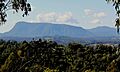
Southern elevation of The Nightcap Range in northern New South Wales; left: Mount Burrell (part); centre: Mount Neville; right: Mount Nardi
|
|
| Highest point | |
| Peak | Mount Burrell |
| Elevation | 933 m (3,061 ft) AHD |
| Dimensions | |
| Length | 25 km (16 mi) SE |
| Geography | |

Location in New South Wales
|
|
| Country | Australia |
| State | New South Wales |
| Range coordinates | 28°33′S 153°20′E / 28.550°S 153.333°E |
| Parent range | Great Dividing Range |

The Nightcap Range is a cool mountain range in the Northern Rivers area of New South Wales, Australia. It sits between the city of Lismore and the border with Queensland. This range is home to important peaks like Mount Burrell and Mount Nardi. It also includes the beautiful Nightcap National Park. Much of the range is covered in old, warm rainforest. You can find some very rare plants here, like the Nightcap oak and the Minyon quandong.
Contents
What is the Nightcap Range?
The Nightcap Range is like a branch coming off the much larger Great Dividing Range. It stretches for about 25 kilometers (15.5 miles) towards the southeast, ending at Peates Mountain. The Nimbin Gap separates it from the rest of the Great Dividing Range.
How was the Nightcap Range formed?
This mountain range forms the southern side of the ancient Mount Warning (Tweed) shield volcano. Geologically, it's made up of different layers of rock. The bottom layer is called Lismore Basalts. On top of that are the Nimbin Rhyolites. The very top layer is the Blue Knob Basalts. These layers show how the volcano erupted and cooled over time.
What are the highest points in the Nightcap Range?
The tallest peak in the Nightcap Range is Mount Burrell, which stands 933 meters (3,061 feet) above sea level. Other important peaks include:
- Mount Neville at 919 meters (3,015 feet)
- Mount Nardi at 812 meters (2,664 feet)
- Mount Matheson at 804 meters (2,638 feet)
- Peates Mountain at 604 meters (1,982 feet)
There's also a spot on Mount Burrell called "Blue Knob." Another cool rock formation nearby is "Sphinx Rock." The names "Blue Knob" and "Mount Burrell" are also used for towns at the base of the range.
What can you find built by people in the Nightcap Range?
The top of Mount Nardi is a busy place! It has several tall towers. These towers are used for FM radio and digital television signals. They also used to send out analogue TV and wireless internet. Some mobile phone services use them too.
Getting to Mount Nardi's summit
You can drive to the summit of Mount Nardi on a paved road. This road was built in 1962 and cost about £32,000. It's a great starting point for many walking trails. One famous trail is the Historic Nightcap walking track. This path was once the main route for travelers and postal workers between Lismore and Murwillumbah.
Water supply and national park
The Nightcap Range is very important for water. It helps collect water for Rocky Creek Dam, which is north of Lismore. This dam provides drinking water for a large part of the Northern Rivers area. The range also contains the beautiful Nightcap National Park, a protected area for nature.
What unique plants live in the Nightcap Range?

The Nightcap Range is the only place in the world where you can find the Nightcap oak. This special tree is part of the Proteaceae plant family. Only about 100 of these wild plants are known to exist. Scientists officially named this tree in 2002. Sadly, a large bushfire in November 2019 damaged much of its home.
The range is also home to most of the known Minyon quandong trees. This is a medium-sized tree in the Elaeocarpaceae family. It's very rare and found in only a few places. It was recognized as a unique species for a while before being formally described in 2008.
Where do the names come from?
Many places in the Nightcap Range have interesting names.
Nightcap
The name "Nightcap" comes from "night camp." The first people who surveyed the range used this term.
Mount Matheson
Mount Matheson is named after George Matheson. He was a government surveyor who, with his assistant Arthur Gracie, mapped the track over the Nightcap Range in the early 1870s.
Mount Burrell
Mount Burrell might get its name from the Aboriginal word "burrul." This word means "wallaby," which is a type of small kangaroo.
Mount Nardi
Mount Nardi is named after Angelo Nardi. He was a local councilor for the Terania Shire from 1956 to 1961.
Images for kids
-
Distant view of Mount Burrell, the westernmost portion of the Nightcap Range
-
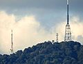
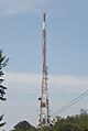
Telephoto view of the three transmission towers on Mount Nardi
-
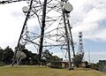
Close-up view of the Mount Nardi transmission towers; from the front: the ABRN6 digital TV tower; the central tower (Telstra-2); the NRN8 (originally: RTN-8) original analogue TV tower
-
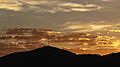
Sunrise over the summit of Mount Nardi from the south, showing the radio and digital television transmission towers
-
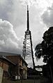
Communications towers on Mount Nardi, New South Wales, Australia: the ABRN-6 tower (digital TV + more)
-
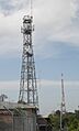
Communications towers on Mount Nardi, New South Wales, Australia: the central tower (Telstra-2)
-
Communications towers on Mount Nardi, New South Wales, Australia: the central tower (Telstra-2) - detail
-
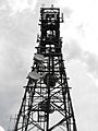
Communications towers on Mount Nardi, New South Wales, Australia: the NRN8 (originally: RTN-8) tower (former analogue TV + other current uses)
-
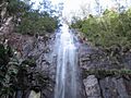
Protestor falls
-
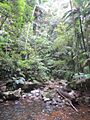
Rainforest at Protesters Falls, Nightcap NP
-
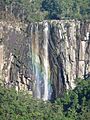
Rainbow through Minyon Falls
-

View at Minyon Falls, Nightcap NP


