
Mount Dickey facts for kids
Quick facts for kids Mount Dickey |
|
|---|---|

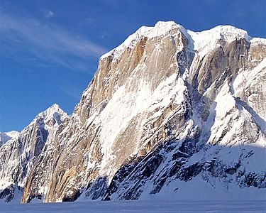
Aerial view of Dickey seen with top of Mount Barrille at bottom of frame
|
|
| Highest point | |
| Elevation | 9,545 ft (2,909 m) |
| Prominence | 2,495 ft (760 m) |
| Geography | |
| Location | Denali National Park and Preserve, Matanuska-Susitna Borough, Alaska, U.S. |
| Parent range | Central Alaska Range |
| Climbing | |
| First ascent | April 19, 1955 by David Fisher, Bradford Washburn |
| Easiest route | West Face: glacier/snow climb |
Mount Dickey is a cool mountain peak in the Alaska Range of mountains. It's located on the west side of the Ruth Gorge. You can find it about 12 miles (19 km) southeast of Denali, which is North America's tallest mountain.
Even though Mount Dickey isn't super tall, it's famous for its amazing east side. This side has a huge, almost straight-up rock wall made of granite. It rises about a mile (1600 meters) straight up in a very short distance. This makes it one of the tallest rock walls in the world! Many expert climbers come here to try very difficult climbs.
Contents
Discovering Mount Dickey
First Climbs and Explorers
Mount Dickey was first climbed on April 19, 1955. The first people to reach the top were David Fisher and Bradford Washburn. Washburn was a very famous explorer, climber, and mapmaker. They climbed the mountain using a path called the West Face route.
The West Face Route
The West Face route is still the most popular way to climb Mount Dickey today. It starts in the Ruth Gorge, then goes around the tough south side of the mountain. After that, it turns and goes up the gentler West Face. This path is quite simple and short for a climb in Alaska. It's also the main way climbers come down after finishing harder routes on the East Face.
Winter Ascents
Climbing mountains in winter is much harder because of the extreme cold and snow. Roger Cowles and Brian Okonek were the first to climb Mount Dickey in winter. They made their successful climb in February 1979.
Challenging East Face Climbs
The East Face of Mount Dickey is known for its extremely difficult rock climbs. Only very skilled climbers attempt these routes.
The First East Face Route
The first route on the East Face was climbed in July 1974. The team included writer and climber David Roberts, photographer and climber Galen Rowell, and Ed Ward. Their route was 5,100 feet (1,554 meters) long and went up a part of the southeast face. Most of their climb took four days to complete.
The Wine Bottle Route
One of the most famous routes on the East Face is called the "Wine Bottle Route." Thomas Bonapace and Andreas Orgler climbed this route in 1988. It's on the right side of the east face and is incredibly technical and long. This route is 5,250 feet (1600 meters) high, making it a huge challenge.
Other Difficult Routes
Since the "Wine Bottle Route" was climbed, many other very challenging paths have been found and climbed on Mount Dickey. These routes continue to attract top climbers from around the world.
Weather in the Mountains
Mount Dickey is in a subarctic climate zone. This means it has very long, cold, and snowy winters. The summers are usually mild. Temperatures can drop below −20 °C (which is -4 °F). With the wind, it can feel even colder, below −30 °C (-22 °F). The best time to visit or climb Mount Dickey is usually from May through June. The weather is often more favorable during these months.
Gallery
-
-
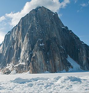
Mt. Dickey from Ruth Glacier
-
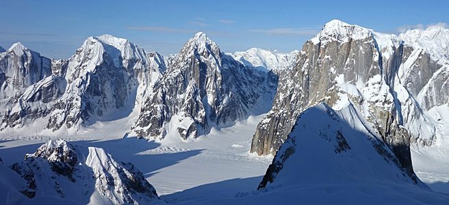
Left to right: Mt. Johnson, Mount Wake, Mt. Bradley, and Mt. Dickey from the east side of Ruth Gorge
-
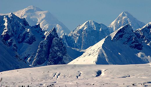
Dickey (center) from Parks Highway. (Hunter left, Huntington right)


.jpg)
