
Mount Barrille facts for kids
Quick facts for kids Mount Barrille |
|
|---|---|

East face of Barrille with Japanese Couloir (left)
|
|
| Highest point | |
| Elevation | 7,650 ft (2,330 m) |
| Prominence | 1,201 ft (366 m) |
| Parent peak | Mount Dickey |
| Geography | |

Mount Barrille
Location in Alaska
|
|
| Location | Denali National Park and Preserve Matanuska-Susitna Borough Alaska, United States |
| Parent range | Alaska Range |
| Topo map | USGS Talkeetna D-2 |
| Type of rock | Granite |
| Climbing | |
| First ascent | July 20, 1957 by Fred Beckey and John Rupley |
| Easiest route | West face |
Mount Barrille is a tall mountain peak in Alaska. It stands at 7,650 ft (2,330 m) high. You can find it in the Alaska Range, inside Denali National Park and Preserve.
This mountain is special because it rises 2,650 ft (808 m) above the Ruth Glacier. It's like a giant guardian at the entrance to a famous area called the Don Sheldon Amphitheater. Mount Barrille is located about 11.43 mi (18 km) southeast of Denali, which is North America's highest peak. It's also near other cool mountains like The Moose's Tooth and Mount Dickey.
The mountain got its name from Edward Barrill (1861-1946). He was a horse packer who traveled with explorer Dr. Frederick Cook. In 1906, Cook claimed he was the first person to climb Denali. Barrill was his only companion on that trip. Later, it was proven that Cook's claim was not true. In 1909, Barrill even signed a paper saying they had not reached the top. Cook wrote about his friend as Barrille, and that spelling is still used today by the United States Geological Survey.
Contents
Climbing Mount Barrille
Even though Mount Barrille isn't the tallest mountain, it's famous for its huge east face. This side of the mountain is almost 2,600 ft (792 m) of straight-up granite rock! It's a popular spot for climbers in the Ruth Gorge. This is partly because it's close to where small planes land and to the Sheldon Chalet, a cozy lodge nearby.
There are many ways to climb Mount Barrille, each with different levels of difficulty.
Japanese Couloir Route
The Japanese Couloir is a well-known route. A couloir is a steep, narrow gully on a mountainside, often filled with snow or ice. This route is considered moderately difficult, with steep snow and ice sections. The first people to climb this route were Teruaki Segawa, Kensei Suga, Masayuki Suemasa, and Eiji Tsai in 1976.
Cobra Pillar Route
Another very popular way to reach the top is the Cobra Pillar. This route goes straight up the middle of the east face. It's called the Cobra Pillar because it looks like a cobra snake from certain angles! This is a very challenging rock climbing route. Jim Donini and Jack Tackle were the first to climb it in June 1991. It took them six days! Later, in June 2004, Joe Puryear and Chris McNamara climbed it in just one day.
Baked Alaskan Route
The Baked Alaskan route is also on the east face. It's another challenging rock climb. Brian Teale and Scott Thelen were the first to complete this route in July 2001.
If you're looking for an easier way down, the west side of the mountain is covered in glacial ice. It's gentle enough that people can even ski down it!
Images for kids
-
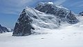
Mt. Barrille (front) with Mt. Dickey behind, as seen from the north at Don Sheldon Amphitheater (formerly Ruth Amphitheater)
-
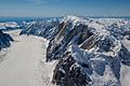
Ruth Glacier, Mt. Dickey, and Mt. Barrille (bottom)
-
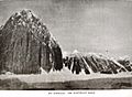
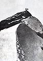
Mount Barrille as it appears in Frederick Cook's book "To the Top of the Continent" (1908)
-
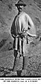
Edward Barrill circa 1908
-
Cook's hoax photo of Ed Barrill atop a peak claimed to be Mt. McKinley


