
Mount Horeb Earthworks Complex facts for kids

Location in Kentucky
|
|
| Location | Lexington, Kentucky, Fayette County, Kentucky, |
|---|---|
| Region | Fayette County, Kentucky |
| Coordinates | 38°9′32″N 84°27′56″W / 38.15889°N 84.46556°W |
| History | |
| Cultures | Adena culture |
| Architecture | |
| Architectural styles | Earthworks |
The Mount Horeb Earthworks Complex is a cool ancient site in Fayette County, Kentucky. It was built by the Adena culture, a group of Native Americans who lived a long time ago. This complex is made up of several large earthworks, which are shapes and mounds built from earth.
The main parts of the complex are the Mount Horeb Site 1 and the Peter Village enclosure. There are also smaller areas like the Grimes Village site. These amazing earthworks were first mapped by explorers like Rafinesque. They were even shown in a famous book called Ancient Monuments of the Mississippi Valley in 1848.
Mount Horeb Site 1: A Special Place
This site is a main part of the University of Kentucky's Adena Park. It sits on a bank about 75 feet (23 meters) above Elkhorn Creek. Imagine a perfectly round platform, about 105 feet (32 meters) across.
This platform is surrounded by a wide ditch and an enclosure. There's a 33-foot (10-meter) wide entrance that faces west. In 1939, archaeologists, who are like history detectives, dug up the site. They found parts of a huge circular wooden building, almost 97 feet (30 meters) wide. Experts think this building might have been a special ceremonial center for the Adena people.
Today, the University of Kentucky owns and takes care of this important historical site.
Peter Village Enclosure: An Ancient Mining Spot
The Peter Village enclosure is another important part of the complex. People first lived here a very long time ago, between 300 and 200 BCE. This was even before the main Adena culture period. It's believed that this site was used to collect and process galena. Galena is a shiny, lead-gray mineral that was important to ancient cultures.
Back then, the site had an earthen fence and a palisade, which is a strong fence made of wooden stakes. Later, a deep ditch was added around it. An early explorer named Rafinesque described this site as a huge, twenty-sided shape. It was about 3,767 feet (1,148 meters) long, surrounded by a ditch that was 15 feet (4.6 meters) wide and up to 8 feet (2.4 meters) deep. The entrance to this enclosure was on the south side.
Old Maps of the Earthworks
The Mount Horeb complex was featured in a very important book from 1848. This book was called Ancient Monuments of the Mississippi Valley. It was written by two explorers, Ephraim George Squier and Edwin Hamilton Davis. They drew detailed maps of ancient sites like these.
-
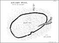
Peter Village enclosure
-
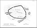
Grimes Village enclosure


