
Mount Misery (Tasmania) facts for kids
Quick facts for kids Mount Misery |
|
|---|---|
 |
|
| Highest point | |
| Elevation | 690 m (2,260 ft) |
| Geography | |
| Location | Tasmania, Australia |
Mount Misery is a really important mountain that you can see from Huonville in southern Tasmania. It's about 690 meters (or 2,260 feet) tall. Even though it's like many other mountains nearby, its special spot near a bend in the Huon River makes it a popular sight for photos.
Contents
Where is Mount Misery?
This mountain sits between a few towns: Lucaston, Ranelagh, and Judbury. It's also connected to other protected areas like the Russell Ridge Conservation Area and even Mount Wellington Park. All the water that flows off Mount Misery ends up in the Huon Valley.
Protecting the Mountain
Who Looks After It?
Mount Misery is part of the Huon Valley Council area. Many people who own land on the mountain care a lot about nature. They have unofficially named their protected area the "Mount Misery Habitat Reserve."
Special Conservation Areas
As of 2017, about half of these landowners have special agreements called "conservation covenants." These agreements help protect the natural environment on their land forever. Tasmania's government created these covenants to make sure important plants and animals are safe for the future.
How the Land is Used
Most of the land on Mount Misery is used for homes where people live close to nature. Some areas are kept just for conservation. A few spots are used for weekend getaways, and one part is even an ecotourism resort.
Plants and Trees
The southern side of Mount Misery has tall, wet eucalyptus forests with small areas of rainforest. These grow in shallow, peaty soil. The northern side is drier, with Eucalyptus tenuiramis trees growing in shallow mudstone soil. Much of the land is also open grassland.
The tops of the trees are usually 20 to 30 meters high. Some trees can even grow to be 50 to 70 meters tall!
Visiting Mount Misery

You can visit Mount Misery by walking on a 5-kilometer (about 3-mile) track. The path goes through a rainforest and then into a high, open area called subalpine heathland. It leads to big rocks at the top of the mountain.
Along the way, there are 30 signs that tell you about the area's Aboriginal history and environmental topics. It takes about three hours to walk to the top. There is no charge to access the track.
You can find the car park and the start of the track at Huon Bush Retreats, on Browns Road in Ranelagh.
Gallery
-
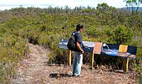
Aboriginal interpretive information on Mount Misery
-
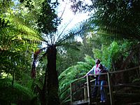
Tree fern bridge, Huon Bush Retreats
-
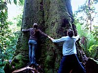
Tree Huggers at Huon Bush Retreats


