Mount Oliver, Pennsylvania facts for kids
Quick facts for kids
Mount Oliver, Pennsylvania
|
|||
|---|---|---|---|
|
Borough
|
|||

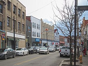
Brownsville Road commercial district in Mount Oliver
|
|||
|
|||

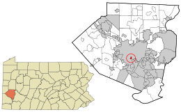
Location in Allegheny County and the U.S. state of Pennsylvania.
|
|||
| Country | United States | ||
| State | Pennsylvania | ||
| County | Allegheny | ||
| Settled | 1769 | ||
| Incorporated | November 9, 1892 | ||
| Area | |||
| • Total | 0.34 sq mi (0.88 km2) | ||
| • Land | 0.34 sq mi (0.88 km2) | ||
| • Water | 0.00 sq mi (0.00 km2) | ||
| Population
(2020)
|
|||
| • Total | 3,394 | ||
| • Density | 10,011.80/sq mi (3,860.12/km2) | ||
| Time zone | UTC-5 (Eastern (EST)) | ||
| • Summer (DST) | UTC-4 (EDT) | ||
| ZIP code |
15210
|
||
| Area code(s) | 412 | ||
| FIPS code | 42-51744 | ||
Mount Oliver is a small town, called a borough, in Allegheny County, Pennsylvania. In 2020, about 3,394 people lived there. It's mostly a place where people live, located on a hill about 3 miles west of the Monongahela River. What's really interesting is that the city of Pittsburgh completely surrounds Mount Oliver. The people of Mount Oliver have always worked hard to stay independent and not become part of Pittsburgh.
Contents
History of Mount Oliver
Mount Oliver was first settled in 1769 by a man named John Ormsby. He was an officer in the army and received a large piece of land near the Monongahela River. In 1788, this land became part of a larger area called St. Clair Township.
How Mount Oliver Got Its Name
Around 1800, John Ormsby started selling parts of his land. He still collected rent and taxes from the people who lived there. Ormsby decided to name his growing settlement "Mount Oliver" after his son, Oliver Ormsby. Later that year, the township was divided. Residents tried to make Mount Oliver its own borough, but the state said no because there weren't enough property owners. So, Mount Oliver became part of Lower St. Clair Township.
Staying Independent from Pittsburgh
In 1872, the big city of Pittsburgh started to grow and take over many smaller towns nearby. This made the people of Mount Oliver worried. They also felt that Lower St. Clair Township wasn't doing enough to fix their roads or keep them safe.
Because of these concerns, a group of residents started a petition in 1892. They wanted Mount Oliver to become its own borough. This petition was approved by the courts on November 9, 1892, and Mount Oliver officially became an independent borough.
In 1927, Pittsburgh tried to expand again, taking over more towns. This meant Mount Oliver was completely surrounded by Pittsburgh. The city even tried to force Mount Oliver to join them through a long legal fight. However, Mount Oliver won! The borough had too many people to be forced into Pittsburgh without its residents voting for it.
To this day, the people of Mount Oliver are very proud of their independence from Pittsburgh. They like that their local government is easy to reach and that services are provided quickly. However, the borough has seen some changes since the 1980s, when it used to be a busy shopping area.
Geography of Mount Oliver
Mount Oliver is located at 40°24′41″N 79°59′12″W / 40.41139°N 79.98667°W. The U.S. Census Bureau says the borough is about 0.3 square miles (0.9 square kilometers) in total. All of this area is land.
Neighborhoods Around Mount Oliver
Mount Oliver is completely surrounded by six different neighborhoods of Pittsburgh. These include:
- The South Side Slopes to the north.
- Arlington to the northeast.
- Mt. Oliver (a Pittsburgh neighborhood with the same name) to the southeast.
- Carrick to the south.
- Knoxville to the west.
- Allentown in the northwest corner.
Population Changes
| Historical population | |||
|---|---|---|---|
| Census | Pop. | %± | |
| 1880 | 1,883 | — | |
| 1900 | 2,295 | — | |
| 1910 | 4,241 | 84.8% | |
| 1920 | 5,575 | 31.5% | |
| 1930 | 7,071 | 26.8% | |
| 1940 | 6,981 | −1.3% | |
| 1950 | 6,646 | −4.8% | |
| 1960 | 5,980 | −10.0% | |
| 1970 | 5,509 | −7.9% | |
| 1980 | 4,576 | −16.9% | |
| 1990 | 4,160 | −9.1% | |
| 2000 | 3,970 | −4.6% | |
| 2010 | 3,403 | −14.3% | |
| 2020 | 3,394 | −0.3% | |
| Sources: | |||
In 2000, there were 3,970 people living in Mount Oliver. These people lived in 1,681 households, and 983 of those were families. The population density was about 11,720 people per square mile.
Most people in Mount Oliver were White (about 83.75%). About 11.74% were African American, and smaller percentages were Native American, Asian, or from other backgrounds. About 1.08% of the population was Hispanic or Latino.
About 28.2% of households had children under 18 living with them. About 33.8% of households were married couples. Many households (41.5%) were not families, meaning they might be single people living alone or roommates.
The average age of people in Mount Oliver in 2000 was 36 years old. About 24% of the population was under 18.
Taxes in Mount Oliver
If you live in Mount Oliver Borough, you pay taxes on the money you earn. Residents pay a 2% tax on their income to the Pittsburgh Public Schools district. They also pay a 1% tax on their income to the Borough of Mount Oliver itself. These taxes help pay for schools and local services in the borough.
See also
 In Spanish: Mount Oliver (Pensilvania) para niños
 | Bayard Rustin |
 | Jeannette Carter |
 | Jeremiah A. Brown |


