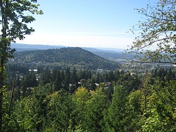
Mount Talbert facts for kids
Quick facts for kids Mount Talbert |
|
|---|---|
 |
|
| Highest point | |
| Elevation | 740+ ft (226+ m) NGVD 29 |
| Prominence | 410 ft (120 m) |
| Geography | |
| Parent range | Cascade Range |
| Topo map | USGS Gladstone |
| Geology | |
| Volcanic arc/belt | Boring Lava Field |
| Last eruption | 500,000 years ago |
Mount Talbert is a special place in Clackamas County, Oregon. It is actually an old volcano! This cone is part of the Boring Lava Field. That's an area with many ancient volcanoes near Portland. The top of Mount Talbert is over 740 feet (226 meters) high.
Explore Mount Talbert Park
Mount Talbert is not built on or developed. Instead, it is a beautiful nature park. The North Clackamas Parks & Recreation District takes care of this park.
Hiking Trails and Nature
The park has 4.2 miles of trails for hiking. Some popular trails include Park Loop, Summit, and West Ridge Trail. As you walk, you will see signs that teach you about the plants and animals there.
Protecting the Trees
In 2005, the park started a special project. They wanted to help white oak trees grow better. These oak trees are more resistant to fire. To help them, park staff carefully removed some Douglas fir trees. The firs were blocking sunlight from reaching the young oak trees. This project helps the forest stay healthy and strong.
 | Victor J. Glover |
 | Yvonne Cagle |
 | Jeanette Epps |
 | Bernard A. Harris Jr. |


