Mount Verstovia facts for kids
Quick facts for kids Mount Verstovia |
|
|---|---|

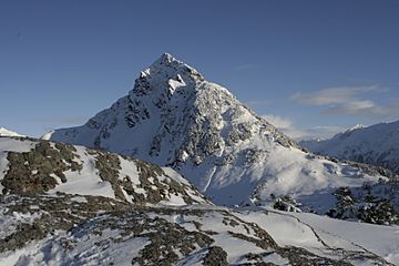
Mt. Verstovia as viewed from "Picnic Rock" (USGS 2,550')
|
|
| Highest point | |
| Elevation | 3,354 ft (1,022 m) |
| Prominence | 1,000 ft (300 m) |
| Geography | |
| Topo map | USGS Sitka A-4 |
| Climbing | |
| Easiest route | Mt Verstovia Trail |
Mount Verstovia is a tall mountain near Sitka, Alaska. It stands on Baranof Island in the Alexander Archipelago. This mountain is just 2.6 miles east of Sitka's town center.
Mount Verstovia is 3,354 feet (about 1,022 meters) high. Its lower parts are covered in old-growth rainforests. Higher up, above 2,400 feet, there are no trees. From these high spots, you can see amazing views of Sitka. You can also see the surrounding mountains and the vast Pacific Ocean.
Contents
What's in a Name?
How Mount Verstovia Got Its Name
A navigator named Ivan Vasiliev first named this peak in 1809. He called it "Gora Verstovaya." In Russian, "Gora" means "mount" or "mountain." A "verst" is an old Russian unit of measurement. It is about 0.66 miles (or 3,500 feet). This measurement is very close to Mount Verstovia's actual height.
Arrow Head Peak
The main top of Mount Verstovia has another name. People in Sitka, Alaska, call it "Arrow Head." This is because it looks like an arrow head pointing upwards. It sits right behind a smaller peak.
The Story of Picnic Rock
Just half a mile west of the main summit is a smaller peak. This peak is 2,550 feet high. In 1869, it was called "Cross Mountain." People say the Russians put a cross there a long time ago. Today, locals call this spot "Picnic Rock." You won't find "Picnic Rock" on official maps. To avoid confusion, a different mountain about 8 miles away is now named "Cross Mountain" on maps.
Exploring Mount Verstovia
Hiking the Trail
Mount Verstovia has a public trail that is well-kept. It starts from Jamestown Bay. The trail goes up for 1.8 miles with many switchbacks. Switchbacks are zigzag turns that help you climb steep hills. This part of the trail leads you to the top of "Picnic Rock."
Reaching the Summit
If you want to go even higher, you can continue to Mount Verstovia's main summit. This part of the trail is about 0.8 miles long. It is not maintained, meaning it can be rough. This section has some steep climbs. You will need basic outdoor skills and good judgment to hike it safely.
Winter Sports Fun
The area between "Picnic Rock" and Mount Verstovia is a popular spot for winter sports. Many people enjoy snowboarding and skiing there. The trail has special reflective signs on tree trunks. These signs help people find their way when there is snow on the ground.
 | Dorothy Vaughan |
 | Charles Henry Turner |
 | Hildrus Poindexter |
 | Henry Cecil McBay |


